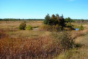
Earth:Burnt Lands alvar
| Burnt Lands Provincial Park | |
|---|---|
IUCN category Ia (strict nature reserve) | |
 Burnt Lands Alvar | |
| Location | Ottawa and Mississippi Mills, Ontario |
| Coordinates | [ ⚑ ] : 45°15′40″N 76°09′00″W / 45.26111°N 76.15°W |
| Area | 516.00 ha (1,275.1 acres) |
| Established | 2003 |
| Governing body | Ontario Parks |
| www | |
The Burnt Lands is an alvar between Almonte and Ottawa near Upper Huntley, Ontario, Canada .[1] It probably obtained its name from one of the forest fires that swept the area during early European settlement.
It is possible that fires assist in creating or maintaining alvars. However, the shallow soil, with alternating drought and flooding, is likely the main factor. The main point is that in a land that is typically covered in forest, alvars provide small area of open prairie-like conditions for plants that require such conditions.
This alvar is one of the best examples of this habitat type in Lanark County and in southern Ontario. It has been the subject of numerous scientific studies.[2][3][4][5][6][7] Because of its significance, The Ontario Ministry of Natural Resources has designated ca 610 hectares (1,500 acres) of the alvar as an Area of Natural and Scientific Interest. A smaller parcel of several hundred hectares is protected within the Burnt Lands Provincial Park (Nature Reserve).[8]
It is a popular destination with local naturalists, including bird-watchers and photographers.[9]
Description
Some of the distinctive plants found here include Cooper's milk vetch[10] and Ram's-Head Ladyslipper. There are 82 breeding bird species and 48 butterfly species. The alvar is thought to have existed in some form since the end of the last ice age, since it has globally rare snails (Vertigo hannai) and even a kind of carabid beetle found nowhere else in the world.[11]
The CFS Carp Almonte Detachment (Almonte Antennae Yard), a decommissioned military radio receiver, was located in the alvar.[12]
Threats to the alvar include urban sprawl, subdivisions, quarries, illegal dumping of household trash and construction materials, illegal sand quarrying, and all-terrain vehicles.[12] There is also a problem with jack pine trees, once planted by the Ontario Ministry of Natural Resources, that are now shading out some of the rare plant species; some experts suggest that these trees need to be removed.[13] A fire in 1999 removed some of the encroaching forest and produced open meadows, which, in 2008 had nearly twice the number of plant species as in adjoining unburned areas.[14]
Burnt Lands Provincial Park
The alvar is protected within the Burnt Lands Provincial Park.[15] The park consists of two non-contiguous parcels of land, totaling 516 hectares (1,280 acres) of land.[8]
It is a non-operating park without any visitor activities or facilities.[8]
See also
- Panmure Alvar - nearby similar alvar
References
- ↑ Keddy, P.A. (2008). Earth, Water, Fire: An Ecological Profile of Lanark County. Motion Creative Printing, Carleton Place, ON. General Store Publishing House, Renfrew, ON. 73 p.
- ↑ Catling, P.M., J.E. Cruise, K.L. McIntosh and S.M. McKay. (1975). "Alvar vegetation in Southern Ontario." Ontario Field Biol. 29(2):1-25.
- ↑ Brunton, D.F. (1986). A life science inventory of the Burnt Lands. Ministry of Natural Resources. 118 pages + 3 maps.
- ↑ Belcher, J., P.A. Keddy, and L. Twolan-Strutt. (1995). "Root and shoot competition along a soil depth gradient." Journal of Ecology 83: 673-682.
- ↑ Belcher, J., P.A. Keddy and P.F.C. Catling. (1992). "Alvar vegetation in Canada: a multivariate description at two scales." Canadian Journal of Botany 70: 1279-1291.
- ↑ Belcher, J. W. and P. A. Keddy. (1992). "Protecting alvar vegetation: will the sum of the parts equal the whole?" p.327-331 in J.H. Willison et al. (eds.) Science and the Management of Protected Areas, Elsevier, Amsterdam.
- ↑ Catling, P.M., A. Sinclair, and D. Cuddy. (2002). "Plant community composition and relationships of disturbed and undisturbed alvar woodland." Canadian Field-Naturalist 116: 571-579.
- ↑ 8.0 8.1 8.2 "Welcome to Burnt Lands Provincial Park" (in en). Ontario Parks. http://www.ontarioparks.com/park/burntlands.
- ↑ "NeilyWorld Birding Ottawa - Mississippi Valley - the Burnt Lands - Ramsey Concession 12 North Page". http://www.neilyworld.com/neilyworld/mississippi11.htm.
- ↑ Michigan Natural Features Inventory.. "Astragalus neglectus". http://mnfi.anr.msu.edu/explorer/species.cfm?id=14115.
- ↑ "22. Burnt Lands Alvar, Almonte". https://www.ottawagatineaugeoheritage.ca/subsites/22.
- ↑ 12.0 12.1 "Burnt Lands Provincial Park Interim Management Statement". Ontario Parks. 2001. https://files.ontario.ca/environment-and-energy/parks-and-protected-areas/mnr_bpp0319.pdf.
- ↑ Keddy, P.A. (2008). Earth, Water, Fire: An Ecological Profile of Lanark County. Motion Creative Printing, Carleton Place, ON. General Store Publishing House Renfrew, ON. 73 p., p.57
- ↑ Catling, Paul M. (2009). "Vascular plant biodiversity in burned and unburned alvar woodland: more evidence of the importance of disturbance to biodiversity and conservation." Canadian Field-Naturalist 123(3): 240–245.
- ↑ "Burnt Lands Provincial Park". Canadian Geographical Names. Natural Resources Canada. http://www4.rncan.gc.ca/search-place-names/unique/FIDQU.
External links
 |

