Earth:Burnt Mountain (Namibia)
From HandWiki
| Burnt Mountain | |
|---|---|
 | |
| Highest point | |
| Coordinates | [ ⚑ ] : 20°37′18″S 14°25′06″E / 20.6216789°S 14.4182253°E |
| Geography | |
| Geology | |
| Age of rock | 80 million years |
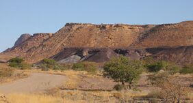
The Burnt Mountain (Afrikaans: Verbrande Berg) is a hill with a solidified lava flow at the foot of a 12-kilometre-long volcanic ridge in Damaraland in northern Namibia.[1] The 80-million-year-old stream of lava was formed by thermal and compression metamorphism and its red, brown, cream and purple colours creates a striking contrast at dusk with the surrounding 200-million-year-old beige rocks of Karoo slate.[2]
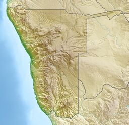
Burnt Mountain rises above the surrounding area by about 200 metres and is not far from the Organ Pipes on the D3254 road and about 10 kilometres southeast of Twyfelfontein.[1]
Since 15 September 1956, the Burnt Mountain has been a National Monument of Namibia.
References
- ↑ 1.0 1.1 Burnt Mountain at www.namibian.org. Retrieved 30 Nov 2017.
- ↑ "The Verbrandeberg and Organ Pipes" (in en). https://www.namibia-accommodation.com/listing/the-verbrandeberg-and-organ-pipes-namibia.
External links
 |


