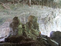
Earth:Caverna de Santana
Caverna de Santana (SP-041), also Caverna de Sant'Anna,[n 1] is a cave located inside the Alto Ribeira Tourist State Park, along the road connecting the towns of Apiaí and Iporanga, to the south of the State of Sao Paulo, Brazil .[1] The Flowers' Hall, displaying thousands of flowers of aragonite, and the Taqueupa Hall as one of the many other formations of great scenic beauty found in the cave, are ranked among the most beautiful and ornated of the world.
History
Discovered and described at the beginning of the twentieth century as "Caverna do Rio Roncador" by the German naturalist Richard Krone,[n 2] it had the potential to become one of the deepest caves in the state, but ended up being one of the most important and visited caves in the country.[2] It is the longest cave within the state area with a horizontal projection of 8.373 meters and unevenness of 61 meters.[3] It is widely used for environmental education tours and photography.
See also
- List of caves in Brazil
References
Notes
Sources
- ↑ Ministerio do Meio Ambiente. "Base de Dados". Icmbio. Archived from the original on 19 April 2012. https://web.archive.org/web/20120419005853/http://www4.icmbio.gov.br/cecav//index.php?id_menu=228. Retrieved 30 December 2011.
- ↑ Grupo Pierre Martin de Espeleologia. "Teto Baixo, Ano I, Vol. I". GPME. http://www.gpme.org.br/documentos/cat_view/18-periodicos-publicados-pelo-gpme/2-teto-baixo. Retrieved 30 December 2011.
- ↑ CBH-RH. "Relatorio de Situacao dos Recursos Hidricos da UGRHI 11". Comite da Bacia Hidrografica do Ribeira do Iguape e Litoral Sul. http://geolig.igc.usp.br/geoproc/rs_ugrhi_rb/app/RS-2_2_3_Prov%EDncia_Espeleol%F3gica_pag50_59.pdf. Retrieved 30 December 2011.[yes|permanent dead link|dead link}}]
External links
- Caverna de Santana - PETAR Online
- Grupo Pierre Martin de Espeleologia
[ ⚑ ] 24°32′00″S 48°42′22″W / 24.5334°S 48.7061°W


