Earth:Fosdick Mountains

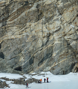
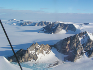
The Fosdick Mountains ( [ ⚑ ] : 76°32′S 144°45′W / 76.533°S 144.75°W) are an east–west trending mountain range with marked serrate outlines, standing along the south side of Balchen Glacier at the head of Block Bay, in the Ford Ranges of Marie Byrd Land, Antarctica. They were discovered by the Byrd Antarctic Expedition in 1929, and named by Richard E. Byrd for Raymond B. Fosdick, who became president of the Rockefeller Foundation.[1]
Glaciers and peaks
- Balchen Glacier
- Ochs Glacier
- Crevasse Valley Glacier
- Demas Bluff
- Mount Avers
- Mount Bitgood
- Mount Colombo
- Mount Ferranto
- Mount Getz
- Mount Iphigene
- Mount Lockhart
- Mount Luyendyk
- Mount Richardson
- Maigetter Peak
- Mount Perkins
Geology and geography
The dominant topography is tall, steep-sided ridges, trending north-south, with peak elevations spanning 1000 to 1200 m.[2] The range consists of the Fosdick Metamorphic Rocks[2] of migmatite gneiss and granite. Metamorphism occurred in the middle of the Cretaceous period.[3] Mount Perkins is a Pleistocene volcano within the range.[4][5]
Further reading
- F. J. Korhonen, S. Saito, M. Brown, C. S. Siddoway, J. M. D. Day, Multiple Generations of Granite in the Fosdick Mountains, Marie Byrd Land, West Antarctica: Implications for Polyphase Intracrustal Differentiation in a Continental Margin Setting, Journal of Petrology, Volume 51, Issue 3, March 2010, Pages 627–670, https://doi.org/10.1093/petrology/egp0939
- Wilbanks, John Randall, Geology of the Fosdick Mountains, Marie Byrd Land, West Antarctica, http://hdl.handle.net/2346/58993
- Clarence N. Fenner, Olivine fourchites from Raymond Fosdick Mountains, Antarctica, GSA Bulletin (1938) 49 (3): 367–400. https://doi.org/10.1130/GSAB-49-367
- Smith, Christine Helen, Cordierite gneisses and high temperature metamorphisms in the Fosdick Mountains, west Antarctica, with implications for breakup processes in the Pacific sector of the Mesozoic Gondwana margin, University of California, Santa Barbara
- Richard, S. M., Smith, C. H., Kimbrough, D. L., Fitzgerald, P. G., Luyendyk, B. P., & McWilliams, M. O. (1994), Cooling history of the northern Ford Ranges, Marie Byrd Land, West Antarctica, Tectonics, 13(4), 837-857
References
- ↑ "Fosdick Mountains". United States Geological Survey. https://geonames.usgs.gov/apex/f?p=gnispq:5:::NO::P5_ANTAR_ID:5170.
- ↑ 2.0 2.1 Wade, F. A., C. A. Cathey, and J. B. Oldham (1977), Reconnaissance geologic map of the Guest Peninsula quadrangle, Marie Byrd Land, Antarctica, Map A-7, U. S. Antarctic Research Program, Reston, VA.
- ↑ Richard, S. M.; Smith, C. H.; Kimbrough, D. L.; Fitzgerald, P. G.; Luyendyk, B. P.; McWilliams, M. O. (1994). "Cooling history of the northern Ford Ranges, Marie Byrd Land, West Antarctica". Tectonics 13 (4): 837–857. doi:10.1029/93tc03322. ISSN 0278-7407. Bibcode: 1994Tecto..13..837R. https://doi.org/10.1029/93TC03322.
- ↑ Siddoway, C., S. Richard, C. M. Fanning, and B. P. Luyendyk. 2004. "Origin and emplacement mechanisms for a middle Cretaceous gneiss dome, Fosdick Mountains, West Antarctica (Chapter 16)." In Gneiss domes in orogeny, edited by D. L. Whitney, C. T. Teyssier and C. Siddoway, 267-294. Geological Society of America Special Paper 380.
- ↑ Luyendyk, B. P., S. M. Richard, C. H. Smith, and D. L. Kimbrough (1992), Geological and geophysical investigations in the northern Ford Ranges, Marie Byrd Land, West Antarctica, in Recent Progress in Antarctic Earth Science: Proceedings of the 6th Symposium on Antarctic Earth Science, Saitama, Japan, 1991, edited by Y. Yoshida, K. Kaminuma and K. Shiraishi, pp. 279-288, Terra Pub., Tokyo, Japan.
External links
- Fosdick Mountains on USGS website
- Fosdick Mountains on SCAR website
- Fosdick Mountains geological map
- Fosdick Mountains satellite image
![]() This article incorporates public domain material from the United States Geological Survey document "Fosdick Mountains" (content from the Geographic Names Information System).
This article incorporates public domain material from the United States Geological Survey document "Fosdick Mountains" (content from the Geographic Names Information System).
 |


