Earth:Grímsnes
| Grímsnes | |
|---|---|
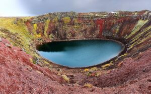
 Kerið - One of many volcanic craters within the volcanic system. | |
| Highest point | |
| Elevation | 214 metres (702 ft) |
| Coordinates | [ ⚑ ] 64°2′N 20°52′W / 64.033°N 20.867°W |
| Geology | |
| Mountain type | Crater rows |
| Last eruption | 3500 BCE |
Grímsnes (Icelandic pronunciation: [ˈkrimsˌnɛːs] (![]() listen)) is a fissure or crater row volcanic system located in South Iceland, a relatively small volcanic system located SE of Thingvallavatn lake east of an en echelon group of volcanic fields extending across the Reykjanes Peninsula. The elevation at its apex is 214 meters. Tephrochronology approximates the volcano's last eruption as 3500 BC.
listen)) is a fissure or crater row volcanic system located in South Iceland, a relatively small volcanic system located SE of Thingvallavatn lake east of an en echelon group of volcanic fields extending across the Reykjanes Peninsula. The elevation at its apex is 214 meters. Tephrochronology approximates the volcano's last eruption as 3500 BC.
The individual volcanoes in the area include Kerið, a lake-filled volcanic crater.
The Grímsneshraun lava-fields in the area cover a total of 54 km2 (21 sq mi). The largest of these plains is the Seyðishólar-Kerhólahraun field which covers 23.5 km2 (9.1 sq mi). Other sizeable plains include the Tjarnarhólahraun field at 11.9 km2 (4.6 sq mi), the Kálfshólahraun field at 8.0 km2 (3.1 sq mi) and the Álftarhólshraun 6.2 km2 (2.4 sq mi). The total volume of lava produced in the lava flows of Grímsnes has been estimated at 1.2 cubic kilometres (0.29 cu mi)
See also
- Geography of Iceland
- List of lakes of Iceland
- Volcanism of Iceland
- List of volcanic eruptions in Iceland
- List of volcanoes in Iceland
External links
- Grímsnes in the Catalogue of Icelandic Volcanoes
[ ⚑ ] 64°2′N 20°52′W / 64.033°N 20.867°W
 |

