Earth:Iliwerung
| Iliwerung | |
|---|---|
 | |
| Highest point | |
| Elevation | 583 m (1,913 ft) |
| Coordinates | [ ⚑ ] 8°31′55″S 123°34′23″E / 8.532°S 123.573°E |
| Geography | |
| Geology | |
| Mountain type | Complex volcano |
| Last eruption | 2021 |
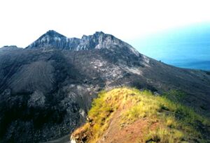
Iliwerung or Illiwerung is a complex volcano forming a prominent south-facing peninsula on Lembata Island in southern Indonesia.[1] It contains north-south and northwest-southeast trending lines of craters and lava domes, with the summit dome having formed by a VEI-3 eruption in 1870.[1][2]
Iliwerung has erupted at least 13 times since 1870, with eruptions having occurred in 1910, 1928, 1948, 1949, 1950, 1951, 1952, 1973-1974, 1976, 1983, 1993, 1999, 2013 and 2021.[2] Eruptions since 1973 have been confined to Hobal, a submarine parasitic vent on Iliwerung's lower east-southeastern flank.[1][2]
Iliwerung lies on the southern rim of the Lerek caldera.[1] A landslide from Iliwerung in 1979 produced 9 m (30 ft) high waves that resulted in more than 500 people killed. In 1983, a tsunami resulting from a submarine eruption caused few deaths.[3]
See also
- List of volcanoes in Indonesia
References
- ↑ 1.0 1.1 1.2 1.3 "Iliwerung: General Information". Smithsonian Institution. https://volcano.si.edu/volcano.cfm?vn=264250.
- ↑ 2.0 2.1 2.2 "Iliwerung: Eruptive History". Smithsonian Institution. https://volcano.si.edu/volcano.cfm?vn=264250.
- ↑ Keeley, J. (2010). "Volcanogenic Tsunamis". Oregon State University. https://volcano.oregonstate.edu/volcanogenic-tsunamis. Retrieved 2022-03-08.
 |


