Earth:Lake Disappointment
| Lake Disappointment | |
|---|---|
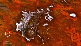
 Landsat image; screen capture from NASA World Wind | |
 | |
| Location | Western Australia |
| Coordinates | [ ⚑ ] : 23°30′S 122°50′E / 23.5°S 122.833°E |
| Lake type | Endorheic salt lake |
| Native name | [Kumpupintil/Kumpupirntily] Error: {{Native name}}: text has italic markup (help) (language?) |
| Basin countries | Australia |
| Max. length | 160 km (99 mi) |
| Surface area | 330 km2 (130 sq mi) |
| Surface elevation | 325 metres (1,066 ft) |

Lake Disappointment, or Kumpupintil/Kumpupirntily[1] in the Western Desert Language, is an endorheic salt lake located in the Pilbara region of Western Australia.
Description
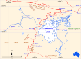
The 33,000-hectare (82,000-acre) lake typically is dry except during very wet periods such as the 1900 floods and in many recent tropical wet seasons since 1967. It lies on the Tropic of Capricorn, due east of the mining town of Template:WAcity and the Template:WAcity. It is at the northern side of the Little Sandy Desert and south of the Karlamilyi National Park. The Canning Stock Route passes down the western shores of the lake and the surrounds consist mostly of sand dunes. Its elevation is 325 metres (1066ft) above mean sea level.[2]
Mythology
In indigenous culture, Kumpupintil was off-limits to the tribes neighbouring the area, such as the Kurajarra, Wanman, Kartudjara and the Putidjara. The reason for the taboo, existing down to modern times, derives from the lake's mythological associations with the Ngayurnangalku spirits thought to live below its surface. This prohibition extended to flying over the area, since the Ngayurnangalku, ancestral cannibal beings with pointy teeth and clawlike fingernails,[3] are deemed capable of ripping even planes that intrude over the lake's airspace.[4]
The lake is home to many species of water birds.[5]
The discovery of a new species of dragon lizard, Ctenophorus nguyarna, at the site was announced in 2007.[6][7]
Name
Lake Disappointment was named by the explorer Frank Hann in 1897.[8] Hann was in the area exploring the east Pilbara, around Rudall River. He noticed creeks in the area flowed inland, and followed them, expecting to find a large fresh water lake. The lake was typically dry and so was named Lake Disappointment.[lower-alpha 1]
See also
- List of lakes of Western Australia
Notes
- ↑ "It was left to Frank Hann in the course of an exploring/prospecting expedition travelling east from Nullagine to sight and name the lake on 20 April 1897. Hann had travelled from Nullagine across the Davis River to the Coolbro Creek, then to the southeast following and naming the Broadhurst Range, crossing the upper Rudall River and the Cotton Creek as far as the Harbutt Range where he turned south to the Mckay Range. Here to the southward he sighted a large lake ten miles distant, and they made their way to it next day, but 'found it was all white salt ... it is the largest thing in lakes I ever saw ... I shall call the lake Lake Disappointment as I was disappointed in not finding water in it."[9]
Citations
- ↑ Tonkinson 1989, p. 106.
- ↑ Beard 2005, p. 62.
- ↑ Nicholls 2014.
- ↑ Tonkinson 1989, p. 109.
- ↑ NGS 2001.
- ↑ Doughty et al. 2007, pp. 72–86.
- ↑ Wilson 2012, p. 66.
- ↑ Rothwell 2003, p. 314.
- ↑ Beard 2005, p. 57, citing "Hann's diary quoted by Donaldson & Elliott, 1998".
Sources
- Beard, J. S. (2005). "Drainage Evolution in the Lake Disappointment Catchment, Western Australia" (PDF). Journal of the Royal Society of Western Australia 88: 57–64. https://www.rswa.org.au/publications/Journal/88(2)/volume88part257-64.pdf.
- Doughty, Paul; Maryan, Brad; Melville, Jane; Austin, Jeremy (2007). "A new species of Ctenophorus (Lacertilia Agamidae) from Lake Disappointment, Western Australia" (PDF). Herpetologica 63 (1): 72–56. https://www.researchgate.net/profile/Brad_Maryan/publication/250069525_A_new_species_of_Ctenophorus_Lacertilia_Agamidae_from_Lake_Disappointment_Western_Australia/links/56317e8108ae0530378d2fb9/A-new-species-of-Ctenophorus-Lacertilia-Agamidae-from-Lake-Disappointment-Western-Australia.pdf.
- "Gibson desert". National Geographic Society. 2001. Archived from the original on 8 March 2010. https://web.archive.org/web/20100308074538/http://www.nationalgeographic.com/wildworld/profiles/terrestrial/aa/aa1303.html.
- Nicholls, Christine Judith (29 April 2014). "'Dreamings' and place – Aboriginal monsters and their meanings". The Conversation. http://theconversation.com/dreamings-and-place-aboriginal-monsters-and-their-meanings-25606.
- Rothwell, Nicolas (2003). Wings of the Kite-Hawk: A Journey Into the Heart of Australia. Black. ISBN 978-1-863-95445-7. https://books.google.com/books?id=0TdGAweCGLgC&pg=PA314.
- Tonkinson, Robert (1989). "Local Organisation and Land Tenure in the Karlamilyi (Rudall River) Region". in Western Desert Working Group. The significance of the Karlamilyi Region to the Martujarra people of the Western Desert. Perth: Department of Conservation and Land Management. pp. 99–259. https://library.dbca.wa.gov.au/static/FullTextFiles/006910.003.pdf.
- Wilson, Steve (2012). Australian Lizards: A Natural History. Csiro Publishing. ISBN 978-0-643-10642-0. https://books.google.com/books?id=NXg0N_vm2W4C&pg=PA66.
