Earth:Lake Killarney (Bahamas)
From HandWiki
| Lake Killarney | |
|---|---|
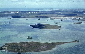
 Lake Killarney can be seen from the air | |
| <mapframe zoom="12" frameless="1" align="center" longitude="-77.435277777778" latitude="25.0425" height="200" width="270">{"type":"Feature","geometry":{"coordinates":[-77.43527777777778,25.0425],"type":"Point"},"properties":{"marker-color":"#5E74F3","title":"Lake Killarney (Bahamas)","marker-symbol":"water"}}</mapframe> | |
| Location | New Providence |
| Coordinates | [ ⚑ ] : 25°02′33″N 77°26′07″W / 25.0425°N 77.43528°W |
| rivers, streams, precipitation">Primary inflows | Canal from Lake Nancy |
| Basin countries | |
| Max. depth | 3 m (9.8 ft) |
Lake Killarney, also known as Petty Lake, is a shallow lake on New Providence Island in the Bahamas, and the largest on the island. Considered hidden from view, it is located just east of Lynden Pindling International Airport. It connects to the smaller Lake Nancy to its north through a canal made for canoeing.
Ecology
Lake Killarney is bounded by marshland and mangrove cays.[1] Bird species such as Coots and ducks rest amongst the mangroves.[2]
References
- ↑ Phillips, Diane (1 March 2019). "Diane Phillips - Lake Killarney: Unseen Beauty Under Threat". http://www.tribune242.com/news/2019/mar/01/diane-phillips-lake-killarney-unseen-beauty-under-/. Retrieved 17 September 2021.
- ↑ "Lake Killarney". https://fishbrain.com/fishing-waters/TAMiIMfK/lake-killarney. Retrieved 17 September 2021.


