Earth:Lake Merrimack
From HandWiki
Short description: Former lake in New Hampshire, United States

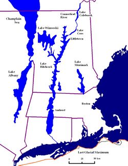
Lake Merrimack was a glacial lake that formed during the late Pleistocene epoch. After the Laurentide Ice Sheet retreated, glacial ice melt accumulated at the terminal moraine and blocked up the Merrimack River, creating the narrow lake. The lake extended from Manchester to Plymouth, New Hampshire. It is unknown when the lake was drained.
Lake Hitchcock is an important part of the geology of New Hampshire. It experienced annual layering of sediments, or varves: silt and sand in the summertime (due to glacial meltwater) and clay in the wintertime (as the lake froze).
See also
- Lake Winnipesaukee
- Champlain Sea
- Lake Albany
- Lake Hitchcock
- Lake Stowe
References
External links
[ ⚑ ] 43°20′N 71°37′W / 43.333°N 71.617°W
 |
