Earth:Lechería Limestone
From HandWiki
| Lechería Limestone Stratigraphic range: Ypresian (Wasatchian-Bridgerian) ~55–48 Ma | |
|---|---|
| Type | Formation |
| Unit of | Río Sabina Group |
| Lithology | |
| Primary | Limestone |
| Location | |
| Coordinates | [ ⚑ ] : 16°54′N 92°54′W / 16.9°N 92.9°W |
| Paleocoordinates | [ ⚑ ] 19°48′N 81°00′W / 19.8°N 81.0°W |
| Region | Chiapas |
| Country | |
| Type section | |
| Named for | Lechería River |
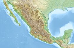
The Lechería Limestone is a geologic formation in Chiapas, Mexico. The shallow reefal biomicrite and mud-supported oolitic and pelletoidal biosparite limestones preserve fossils dating back to the Paleogene period.[1]
See also
- List of fossiliferous stratigraphic units in Mexico
- Klondike Mountain Formation
- Nanjemoy Formation
- Bogotá Formation
References
- ↑ Soyalo road section at Fossilworks.org
Further reading
- S. H. Frost and R. L. Langenheim, Jr. 1974. Cenozoic Reef Biofacies. Chicago, Northern Illinois University Press 1-388
 |


