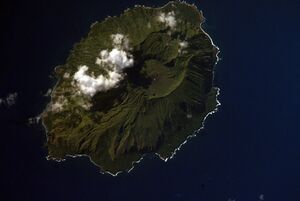
Earth:Mount Agrihan
From HandWiki
[ ⚑ ] 18°46′N 145°40′E / 18.77°N 145.67°E
Short description: Volcano in Northern Mariana Islands
| Mount Agrihan | |
|---|---|
 NASA Space Shuttle image of Agrihan | |
| Highest point | |
| Elevation | 3,166 ft (965 m) [1] |
| Prominence | 3,166 ft (965 m) |
| Coordinates | [ ⚑ ] 18°46′N 145°40′E / 18.77°N 145.67°E |
| Geography | |
| Location | Northern Mariana Islands, United States |
| Geology | |
| Mountain type | Stratovolcano |
| Last eruption | 1917 |
| Climbing | |
| First ascent | 2018; organized by John D. Mitchler and Reid Larson |
Mount Agrihan is a stratovolcano on the formerly uninhabited island of Agrihan in the Pacific Ocean, located in the Northern Mariana Islands, an insular area and commonwealth of the United States . The volcano has an elevation of 3,166 feet (965 m),[1] making its summit the highest point in the Northern Mariana Islands, as well as all of Micronesia.
History
The volcano's last known eruption was in 1917.[1]
An expedition organized by John D. Mitchler and Reid Larson made the first complete ascent to the summit of this peak on June 1, 2018.[2]
References
- ↑ 1.0 1.1 1.2 "Agrigan". Smithsonian Institution. https://volcano.si.edu/volcano.cfm?vn=284160.
- ↑ Frick-Wright, Peter (15 January 2019). "The Obsessive Quest of High Pointers". Outside. https://www.outsideonline.com/2379686/high-pointers.
 |

