Earth:Mount Ashitaka
From HandWiki
Short description: Eroded Stratovolcano southeast of Mount Fuji
| Mount Ashitaka | |
|---|---|
 Southeast Side | |
| Highest point | |
| Peak | Mount Echizen-dake |
| Elevation | 1,504 m (4,934 ft) |
| Dimensions | |
| Length | 7 km (4.3 mi) Southwest-Northeast |
| Width | 6 km (3.7 mi) Northwest-Southeast |
| Naming | |
| Native name | [愛鷹山 (Japanese)] Error: {{Native name}}: missing language tag (help) (language?) |
| Geography | |
| Country | Japan |
| Prefecture | Shizuoka |
| Range coordinates | [ ⚑ ] : 35°13′37″N 138°48′11″E / 35.227°N 138.803°E |
 Ashitaka Mount Ashitaka (Japan) | |
Mount Ashitaka (愛鷹山, Ashitakayama) is an eroded stratovolcano in the area south-east of Mount Fuji, Japan . Its highest peak, 1,504 metres (4,934 ft) high,[1] is Mount Echizen-dake, but the complex is named after its secondary peak, Ashitaka-yama, 1,188 m (3,898 ft) high.
Detailed map

Echizendake(1504)
Ashitaka(1188)
Ihaidake(1458)
Kurodake(1087)
Ōtake(1262)
Yobikodake(1310)
Maedake(1336)
Topographic map of Ashitaka Volcano
Gallery
-
 From the south.
 -
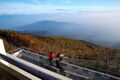
 From above
 -
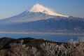
 From Mount Fuji


.jpg)
See Also
- List of volcanoes in Japan
- List of mountains in Japan
References
- ↑ Karátson, D. "Erosion calderas: origins, processes, structural and climatic control," Bulletin of Volcanology Vol. 61 (1999), pp. 179 [PDF 6 of 20]; Retrieved 2012-6-21.
The page incorporated material from Japanese Wikipedia page 愛鷹山, accessed 23 April 2019
External links
- "Ashitaka". Smithsonian Institution. https://volcano.si.edu/volcano.cfm?vn=283822.
- Ashitaka Yama - Geological Survey of Japan
 |

