Earth:Mount Zaō
| Zaō Mountains | |
|---|---|
| 蔵王連峰 | |
Lua error in Module:Location_map at line 522: Unable to find the specified location map definition: "Module:Location map/data/Japan Tohoku" does not exist.
| |
| Highest point | |
| Elevation | 1,841 m (6,040 ft) [1][2] |
| Listing |
|
| Coordinates | [ ⚑ ] : 38°08′38″N 140°26′24″E / 38.144°N 140.44°E [1] |
| Geography | |
| Country | Japan |
| Island | Honshu |
| Prefectures |
|
| Geology | |
| Mountain type | Complex volcano |
| Volcanic arc | Northeastern Japan Arc |
| Last eruption | May 1940[1] |
The Zaō Mountains (蔵王連峰, Zaō Renpō), commonly called Mount Zaō, are a complex cluster of stratovolcanoes on the border between Yamagata Prefecture and Miyagi Prefecture in Japan. The central volcano (one of the 100 Famous Japanese Mountains) includes several lava domes and a tuff cone, Goshiki-dake, which contains a crater lake named "Okama". Also known as the "Five Color Pond" (五色沼, goshiki numa) because it changes color depending on the weather, it lies in a crater formed by a volcanic eruption in the 1720s. The lake is 360 metres (1,200 ft) in diameter and 60 m (200 ft) deep, and is one of the main tourist attractions in the area.
One striking feature of Zaō's famous ski resorts are the "frost-covered trees" (樹氷, juhyō) that appear in mid-winter. Mount Zao is, together with Mount Hakkoda and Mount Moriyoshi, regarded as one of the "Three Great Frost-Covered Tree" (Nihon Sandai Juhyō, 日本三大樹氷) sites of Japan, where the phenomenon known as "snow monsters" can be observed. At each mountain, aerial lift operated by the respective ski resorts provide access to areas in close proximity to the frost-covered trees.[3] Strong wind over the nearby lake fling water droplets which freeze against the trees and their branches, until near-horizontal icicles begin to form. Falling snow settles on the ice formations, with the end result being grotesque figure of a tree. The effect of a full forest of such trees gives visitors a ghostly impression, hence they are colloquially known as "snow monsters". Formed under precise meteorological and ecological conditions almost unique to northern Japan, the phenomenon is has been decreasing due to climate change.[4]
Rotaria rotatoria[5] and Pinnularia spp.[6] are found in the acidic Okama Lake.[7]
-
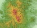 Relief Map
 -
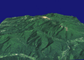 A 3D rendering
 -
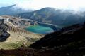 Okama Crater
 -
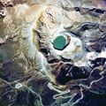 Okama Crater
 -
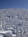 Snow monsters
 -
Snow monsters up close
-
Zaō Ropeway soft rime


See also
- Snow country (Japan)
- Zaō Ropeway
References
- ↑ 1.0 1.1 1.2 "Zaozan [Zaosan"]. Smithsonian Institution. https://volcano.si.edu/volcano.cfm?vn=283190.
- ↑ "Topographic map of Zao". https://opentopomap.org/#marker=14/38.14391/140.43973.
- ↑ "幻想的な雪の世界へ! 森吉山樹氷×秋田内陸線 冬の絶景旅に出かけよう". JR East. https://www.jreast.co.jp/akita/meettheheart/column/article103.html.
- ↑ "'Nothing else looks like them': Saving Japan's exceptionally rare 'snow monsters'". Dec 4, 2025. https://www.bbc.com/future/article/20251203-japans-disappearing-snow-monsters.
- ↑ Deneke, Rainer (2000). "Review of rotifers and crustaceans in highly acidic environments of pH values ≤ 3". Hydrobiologia 433 (1–3): 167–172. doi:10.1023/a:1004047510602.
- ↑ Negoro, K (1940). "A Pinnularia from Okama, an acidotrophic crater lake of volcano Zao". Jpn. J. Limnol. 9 (4): 176–179. doi:10.3739/rikusui.9.176.
- ↑ Anzai, T (1938). "Limnological observation of Okama, a crater lake of Volcano Zaō". Jpn. J. Limnol. 8 (3–4): 264–272. doi:10.3739/rikusui.8.3-4_264.
External links
- "English Travel information on Mt. Zao". 21 April 2022. https://www.thehiddenjapan.com/zao.Script error: The function "in_lang" does not exist.
- Zaozan - Japan Meteorological Agency Script error: The function "in_lang" does not exist.
- "Zaozan: National catalogue of the active volcanoes in Japan". http://www.data.jma.go.jp/svd/vois/data/tokyo/STOCK/souran_eng/volcanoes/033_zaozan.pdf. - Japan Meteorological Agency
- "Zao" (in ja). Geological Survey of Japan. https://gbank.gsj.jp/volcano/Act_Vol/zao/text/exp-1.html.
| Hokkaidō | |||||||||
|---|---|---|---|---|---|---|---|---|---|
| Tōhoku region Jōshinetsu region |
| ||||||||
| Kantō region | |||||||||
| Chūbu region |
| ||||||||
| Western Japan | |||||||||
| |||||||||
 |  |
