Earth:North Bay Outlet
From HandWiki

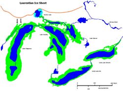
The North Bay Outlet was an outlet of a proglacial lake that preceded present day Lake Huron, where it discharged its waters near present day North Bay, rather than a more southerly route, as the Laurentian glaciation receded.[1][2] Water drained down this route from approximately 10000 to 4500 bpe.
Glacial rebound raised the land around the outlet, leading to increased water levels in the lake, and finally the lake water finding a lower outlet.[1]
References
- ↑ 1.0 1.1 "THE NIPISSING GREAT LAKES". Michigan State University. http://geo.msu.edu/extra/geogmich/glaciallake_nip.html. Retrieved 2019-11-23. "These lakes started forming as the North Bay outlet opened up, effectively draining Glacial Lake Algonquin down to the Chippewa-Stanley level. With time, from 10,000 BP to about 4500 BP, the outlet rose, due to isostatic rebound."
- ↑ Paul F. Karrow (2005-07-25). "Algonquin-Nipissing Shorelines, North Bay, Ontario". Erudit. https://www.erudit.org/en/journals/gpq/1900-v1-n1-gpq1285/013144ar/. Retrieved 2019-11-23. "Terasmae and Hughes (1960) used palynology, radiocarbon dates from isolation basin basal organic sediments, and varves to conclude the North Bay outlet was deglaciated between 11 000 and 10 000 BP.".
