Earth:Plantmaps
Type of site | Gardening, Botany, Agriculture, Horticulture |
|---|---|
| Available in | English |
| Website | www |
| Launched | Script error: No such module "Date time". |
| Current status | Active |
Plantmaps.com is reference website that contains several interactive maps and tools to assist gardeners, botanists, farmers and horticulturalists. By entering a ZIP code, users can find the USDA hardiness zone, first and last frost dates, heat zones, drought conditions and annual climatology for their area.
Website tools
Interactive USDA Hardiness Zone map

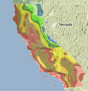
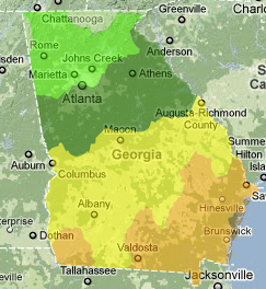
built using the google maps api, plantmaps.com has the only fully interactive USDA hardiness zones map available on the web. In addition to plant hardiness zone map covering the continental United States, there are detailed interactive hardiness zone maps for each individual state. Plantmaps allows the user to locate their hardiness zone based on current US Postal Service ZIP codes. The ZIP code search will zoom to the coverage area of the selected ZIP code.
Hardiness Zone to ZIP code search
Plantmaps allows other websites to embed the USDA hardiness zone to ZIP code search tool in their websites by adding an iframe widget to their site, allowing visitors to easily find their local hardiness zone.
Plantmaps zones

In response to the latency of the current official USDA hardiness zone map (produced in 1990 using data from 1974 to 1986),[3] plantmaps has created a new hardiness zone map using historical data from the National Climatic Data Center that covers longer time periods and uses climate record data from as recently as 2009. There is an updated plantmaps hardiness zones map for each individual state in the Continental US.
Interactive first and last frost maps
Using long term climatology data from the National Climatology Data Center, Plantmaps has created interactive average annual first frost and average annual last frost date maps for each individual state. These maps break the average frost dates into 10 day/date increments.
Interactive drought monitor
Using shapefile data available from the National Drought Mitigation Center,[4] plantmaps has created statewide interactive Drought Monitor Maps that are updated weekly with the latest drought monitor conditions throughout the US.
Interactive Palmer Drought Index map
Plantmaps provides an interactive Palmer Drought Index map for each state. The interactive drought index maps use the latest data supplied by the National Oceanic and Atmospheric Administration and allows the map user to select and highlight the specific climate divisions in each state.
Interactive ecoregions
Plantmaps has created interactive versions of all available level IV Environmental Protection Agency ecoregion maps that allow the user to zoom to identify each individual region. Ecoregions denote areas within which ecosystems (and the type, quality, and quantity of environmental resources) are generally similar.[5] Currently, level IV maps are available for all states except Arizona, California, Hawaii and Alaska.
Interactive heat zone maps
Plantmaps contains interactive heat zone maps for each state. Heat zones display the average frequency of annual days where the temperature exceeds 86 degrees fahrenheit. Heat zones are useful for determining the survivability of specific plants and trees in extreme temperature conditions. It is also useful for determining suitability for plants and trees such as palm trees that require warm temperatures for growth.
Interactive tree and plant distribution maps
Plantmaps has interactive plant and tree distribution maps for 800 North American flora. The distribution maps contain overlays of USDA hardiness zones for analysis of plant and tree range versus hardiness zone.
Canada Hardiness Zone Map
In January 2011, Plantmaps released an interactive Canada plant hardiness zone map using up to date climatology data from Canadian National Climate Data Archive.
References
- ↑ "California USDA Hardiness Zone Map". Plantmaps. http://www.plantmaps.com/interactive-california-usda-plant-zone-hardiness-map.php. Retrieved 2010-12-05.
- ↑ "Interactive Plantmaps 2009 Plant Hardiness Zone Map for Georgia". Plantmaps. http://www.plantmaps.com/interactive-georgia-plant-maps-zone-hardiness-map.php. Retrieved 2010-12-05.
- ↑ "US National Arboretum". US National Arboretum. http://www.usna.usda.gov/Hardzone/. Retrieved 2010-11-11.
- ↑ "US Drought Monitor". National Drought Mitigation Center. http://drought.unl.edu/dm/monitor.html. Retrieved 2010-11-11.
- ↑ "US EPA Ecoregions". EPA. http://www.epa.gov/wed/pages/ecoregions.htm. Retrieved 2010-11-11.
External links
- Plantmaps 2010 Plant Hardiness Zone Map
- Hardiness Zone to Zipcode Search Widget
- Canada 2010 Plant Hardiness Zone Map
- Interactive version of the USDA Plant Hardiness Zone Map
