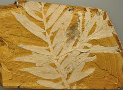
Earth:Purlawaugh Formation
From HandWiki
Short description: Geologic formation in New South Wales
| Purlawaugh Formation Stratigraphic range: Toarcian-Oxfordian | |
|---|---|
 Fossil plant (agathis jurassica) from the Purlawaugh Formation | |
| Type | Geological formation |
| Sub-units | Comiala Shale & Merrygoen Ironstone Members |
| Underlies | Pilliga Sandstone |
| Overlies | Garrawilla Volcanics |
| Thickness | Up to 100 m (330 ft) |
| Lithology | |
| Primary | Sandstone |
| Other | Siltstone, mudstone, coal |
| Location | |
| Coordinates | [ ⚑ ] : 32°12′S 149°42′E / 32.2°S 149.7°E |
| Paleocoordinates | [ ⚑ ] 73°06′S 84°06′E / 73.1°S 84.1°E |
| Region | New South Wales |
| Country | |
| Extent | Surat Basin |
| Lua error in Module:Location_map/multi at line 27: Unable to find the specified location map definition: "Module:Location map/data/New South Wales" does not exist. | |
The Purlawaugh Formation is a Toarcian to Oxfordian geologic formation of New South Wales, Australia. The formation has provided many fossil fish and flora at the Talbragar fossil site.[1]
References
- ↑ Talbragar Beds at Fossilworks.org
External links
 |

