Earth:Rumiñahui (volcano)
From HandWiki
| Rumiñahui | |
|---|---|
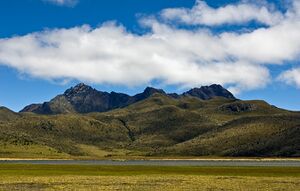
 Rumiñawi as seen from the lake Limpiopunku | |
| Highest point | |
| Elevation | 4,721 m (15,489 ft) |
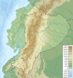
| Coordinates | [ ⚑ ] : 00°38′S 78°32′W / 0.633°S 78.533°W |
| Naming | |
| English translation | stone eye |
| Language of name | Quechua |
| Geography | |
| Parent range | Andes |
| Geology | |
| Mountain type | Stratovolcano |
Rumiñahui (/ruːmiˈnjɑːwiː/ roo-mee-NYAH-wee, Kichwa rumi stone, rock, ñawi eye, face,[1] "stone eye", "stone face", "rock eye" or "rock face", Hispanicized spelling Rumiñahui, Spanish pronunciation: [rumiˈɲawi]) is a dormant, heavily eroded stratovolcano 4,721 metres (15,489 ft) above sea level. Situated in the Andes mountains 40 km south of Quito, Ecuador, it is overshadowed by its famous neighbour Cotopaxi.
See also
- Rumiñahui
- Lists of volcanoes
- List of volcanoes in Ecuador
- List of stratovolcanoes
Latagunga
Sources
- ↑ Kichwa Yachakukkunapa Shimiyuk Kamu (Ministry of Education, Ecuador)
External links
- photos and general information on the mountain
- "Rumiñahui". Smithsonian Institution. https://volcano.si.edu/volcano.cfm?vn=352814.


