Earth:Topographic isolation
From HandWiki
Short description: Minimum horizontal distance to a point of equal elevation

A - Nearest higher neighbour
The topographic isolation of a summit is the minimum horizontal distance to a point of equal elevation, representing a radius of dominance in which the peak is the highest point. It can be calculated for small hills and islands as well as for major mountain peaks and can even be calculated for submarine summits. Mount Everest, the highest point on Earth, has an undefined isolation, since there are no higher points to reference.[1]
Because topographic isolation can be difficult to determine, a common approximation is the distance to a peak called the nearest higher neighbour (NHN).[2]
Isolation table
The following sortable table lists Earth's 40 most topographically isolated summits.
| Rank | Summit | Landmass | Country | Elevation | Prominence | Isolation | Nearest higher neighbour |
|---|---|---|---|---|---|---|---|
| 1 | Mount Everest | Eurasia | n/a | ||||
| 2 | Aconcagua | South America | Tirich Mir (Khyber Pakhtunkhwa, Pakistan) | ||||
| 3 | Denali (Mount McKinley) | North America | Yanamax (Xinjiang, China) | ||||
| 4 | Kilimanjaro | Africa | Kuh-e Shashgal (Afghanistan) | ||||
| 5 | Puncak Jaya | New Guinea | Jade Dragon Snow Mountain (Yunnan, China) | ||||
| 6 | Vinson Massif | Antarctica | File:Flag of Antarctica.svg Antarctica | Risco Plateado (Mendoza, Argentina) | |||
| 7 | Mont Orohena | Tahiti | Mount Ngauruhoe (New Zealand) | ||||
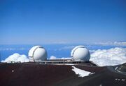
| 8 | Mauna Kea | Hawai'i | Mount Shasta (California, US) | ||||
| 9 | Gunnbjørn Fjeld | Greenland | The Eiger (Canton of Bern, Switzerland) | ||||
| 10 | Aoraki / Mount Cook | South Island | Mount Adam (Victoria Land, Antarctica) | ||||
| 11 | Thabana Ntlenyana | Africa | Mount Meru (Tanzania) | ||||
| 12 | Maunga Terevaka | Easter Island | Cerro de Los Inocentes (Alejandro Selkirk Island, Chile) | ||||
| 13 | Mont Blanc | Eurasia | Kukurtlu Dome (ru) (Karachay-Cherkessia, Russia) | ||||
| 14 | Piton des Neiges | Réunion | Giant's Castle (KwaZulu-Natal, South Africa) | ||||
| 15 | Klyuchevskaya Sopka | Eurasia | Mount Foraker (Alaska, US) | ||||
| 16 | Pico de Orizaba | North America | Pico Cristóbal Colón (Magdalena Department, Colombia) | ||||
| 17 | Queen Mary's Peak | Tristan da Cunha | Mount Paget (South Georgia Island, UK) | ||||
| 18 | Mount Whitney | North America | Nevado de Toluca (State of Mexico, Mexico) | ||||
| 19 | Gunung Kinabalu | Borneo | Ngga Pilimsit (Papua, Indonesia) | ||||
| 20 | Mount Elbrus | Eurasia | Pik Agasis (Tajikistan) | ||||
| 21 | Pico da Bandeira | South America | Cerro Naranjos (es) (Bolivia) | ||||
| 22 | Mont Cameroun | Africa | Mikeno (Democratic Republic of the Congo) | ||||
| 23 | Mount Paget | South Georgia | Welch Mountains (Palmer Land, Antarctica) | ||||
| 24 | Mauga Silisili | Savai'i | Tabwemasana (Vanuatu) | ||||
| 25 | Nevado Huascarán | South America | Tres Cruces (Chile/Argentina border) | ||||
| 26 | Anamudi | Eurasia | Machapuchare (Nepal) | ||||
| 27 | Jebel Toubkal | Africa | Picco Luigi Amedeo (Italy) | ||||
| 28 | Mount Fuji | Honshu | Xueshan (Taiwan) | ||||
| 29 | Emi Koussi | Africa | Mount Cameroon (Cameroon) | ||||
| 30 | Mawson Peak | Heard Island | Mount McMaster (Enderby Land, Antarctica) | ||||
| 31 | Mount Mitchell | North America | Lone Butte (Colorado, US) | ||||
| 32 | Gunung Kerinci | Sumatra | Gunung Kinabalu (Sabah, Malaysia) | ||||
| 33 | Joe's Hill | Kiritimati | Puu Ki (Hawaii, US) | ||||
| 34 | Agrihan High Point | Agrihan | Mount Amagi (Chūbu, Japan) | ||||
| 35 | Mount Kosciuszko | Australia | Tutoko (New Zealand) | ||||
| 36 | Olavtoppen | Bouvet Island | Template:BVT | Edinburgh Peak (Gough Island, South Atlantic Ocean) | |||
| 37 | Mascarin Peak | Marion Island | Cockscomb (Eastern Cape, South Africa) | ||||
| 38 | Green Mountain | Ascension Island | Mount Richard-Molard (Ivory Coast/Guinea border) | ||||
| 39 | Gora Narodnaya | Eurasia | Kattotjåkkå (Sweden) | ||||
| 40 | Yushan | Taiwan | Peak 4030 (Yunnan, China) |
Examples
- The nearest peak to Germany's highest mountain, the 2,962-metre (9,718 ft) high Zugspitze, that has a 2,962-metre (9,718 ft) contour is the 2,988-metre (9,803 ft) Zwölferkogel in Austria's Stubai Alps. The distance between the Zugspitze and this contour is 25.8 kilometres (16 mi); the Zugspitze is thus the highest peak for a radius of 25.8 kilometres (16 mi). Its isolation is thus 25.8 kilometres (16 mi).
- Because there are no higher mountains than Mount Everest, it has no definitive isolation. Many sources list its isolation as the circumference of the Earth over the poles or – questionably, because there is no agreed definition – as half the Earth's circumference.
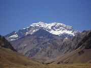
- After Mount Everest, Aconcagua, the highest mountain of the Americas, has the greatest isolation of all mountains. There is no higher land for 16,534 kilometres (10,274 mi). Its height is first exceeded by Tirich Mir in the Hindu Kush.
- Mont Blanc is the highest mountain of the Alps. The geographically nearest higher mountains are all in the Caucasus. Kukurtlu Dome (ru), 4,978 metres (16,332 ft), is the reference peak for Mont Blanc.
- Musala is the highest peak in Rila mountain, also in Bulgaria and the Balkan Peninsula mountain system; standing at 2,925 m (9,596 ft) it is the fourth-most topographically isolated major peak in Continental Europe.[3] With a topographic prominence of 2,473 metres (8,114 ft), Musala is also the sixth-highest peak by topographic prominence in mainland Europe.[4]
Gallery
-
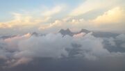
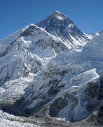 1. Mount Everest is the highest mountain peak on Earth.
 -
-
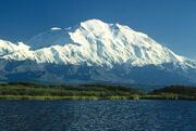 3. Denali is the highest peak of North America.
 -
 4. Kilimanjaro is the highest peak of Africa.
 -

-
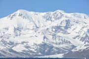
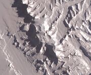 6. The Vinson Massif is the highest peak of Antarctica.
 -
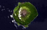
 7. Mont Orohena on Tahiti is the highest peak of French Polynesia.
 -
-

-
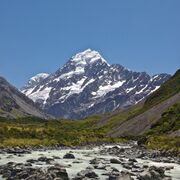 10. Aoraki, or Mount Cook, on the South Island is the highest peak in New Zealand.
 -
 11. Thabana Ntlenyana in Lesotho is the highest point in southern Africa.
 -
 12. Ma′unga Terevaka is the highest point on Easter Island.
 -
 13. Mont Blanc is the highest peak of Western Europe.
 -
 14. Piton des Neiges is the apex of Réunion.
 -
 15. Klyuchevskaya Sopka is the highest peak of Kamchatka.
 -
 16. Pico de Orizaba is the highest peak of Mexico.
 -
 17. Queen Mary's Peak is the highest point on the Atlantic island of Tristan da Cunha.
 -
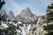 18. Mount Whitney is the highest peak of the contiguous United States.
 -
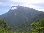 19. Gunung Kinabalu is the apex of Borneo.
 -
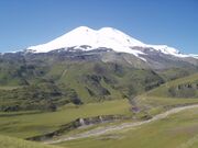 20. Mount Elbrus is the highest peak of Europe.
 -
 21. Pico da Bandeira is the third highest peak of Brazil.
 -
 22. Mount Cameroon is the highest peak of Cameroon.
 -
 23. Mount Paget on South Georgia is the highest peak in the South Atlantic Ocean.


See also
- Most isolated major summits of Europe
- Table of the most isolated major summits of North America
- Table of the most isolated major summits of the United States
- Most isolated mountain peaks of Canada
- Most isolated mountain peaks of Mexico
- Geodesy
- Physical geography
- Summit (topography)
- Topographic elevation
- Topographic prominence
- Topography
References
- ↑ Kirmse, Andrew; de Ferranti, Jonathan (December 2017). "Calculating the prominence and isolation of every mountain in the world". Progress in Physical Geography: Earth and Environment 41 (6): 788–802. doi:10.1177/0309133317738163. https://journals.sagepub.com/doi/10.1177/0309133317738163. Retrieved 8 May 2024.
- ↑ Nearest higher neighbour in glossary on www.peakbagger.com
- ↑ "Most Isolated Peak of Europe Countries - Peakbagger.com". https://www.peakbagger.com/list.aspx?lid=337.
- ↑ "Europe Ultra-Prominences". Peaklist. http://www.peaklist.org/WWlists/ultras/EuroCoreP1500m.html.
External links
- bivouac.com Canadian Mountain Encyclopedia
- peakbagger.com
- peaklist.org
- peakware.com World Mountain Encyclopedia
- summitpost.org
 |  |
