Engineering:MV Prestige
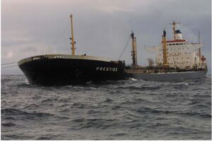
 The MV Prestige under emergency tow shortly before it sank in November 2002
Script error: The function "infobox_ship_career" does not exist. | |
| General characteristics | |
|---|---|
| Type: | Aframax Single-Hull |
| Tonnage: | 81,589 DWT[1] 42,820 GT[1] |
| Length: | 243 m (797 ft)[1] |
| Beam: | 34.4 m (113 ft)[1] |
| Draft: | 14 m (46 ft)[1] |
| Depth: | 18.7 m (61 ft)[1] |
| Installed power: | |
| Propulsion: | Burmeister and Wain Type 8K84EF, 8 cylinder diesel, 14,711 KW [2] |
| Speed: | 15.4 knots (28.5 km/h; 17.7 mph)[1] |
| Crew: | 27 |
| Notes: | Use of Maltese Cross by ABS |
The MV Prestige was an oil tanker owned by a Greek company based in Athens and operating under a Bahamian flag, that on 19 November 2002 sank off the coast of Galicia, Spain . The sinking caused a major environmental disaster, polluting thousands of miles of coastline with 50,000 tonnes of oil.[3]
Design and construction
Prestige was a single-hulled oil tanker with a length overall of 243 metres (797 ft), a beam of 34.4 metres (113 ft), a hull depth of 18.7 metres (61 ft), and a draft of 14 metres (46 ft). It had a 42,820 GT and a total cargo capacity of 81,589 tonnes deadweight (DWT).
The ship was launched on 10 December 1975 and completed on 30 March 1976 by Hitachi Shipbuilding and Engineering Co. in Maizuru, Kyoto, Japan. At the time of its sinking, it was owned by Mare Shipping, and registered in the Bahamas.[4]
See also
- Prestige oil spill
- List of oil spills worldwide
- Plataforma Nunca Máis
- Aegean Sea: another oil tanker that sank off the Galician coast in 1992
References
- ↑ 1.0 1.1 1.2 1.3 1.4 1.5 1.6 Cite error: Invalid
<ref>tag; no text was provided for refs namedmultiple - ↑ 2.0 2.1 2.2 Cite error: Invalid
<ref>tag; no text was provided for refs namedBahamas Prestige Investigation - ↑ "Spain Prestige oil spill disaster case in court". BBC News. 16 October 2012. https://www.bbc.co.uk/news/world-europe-19952329. Retrieved 2016-02-04.
- ↑ "Prestige (7372141)". Miramar Ship Index. https://www.miramarshipindex.nz/ship/7372141.
External links
- Prestige at the Ministry of the Sea (Galicia) (Xunta de Galicia)
- The Prestige: one year on, a continuing disaster a report by the World Wide Fund for Nature
- Prestige Ship Structure Case Study
[ ⚑ ] 42°53′N 9°53′W / 42.883°N 9.883°W
 |
