File:Last Ice Area NOW.tif
From HandWiki

Size of this preview of this TIF file: 298 × 419 pixels. Other resolution: 224 × 315 pixels.
Original file (1,497 × 2,105 pixels, file size: 12.02 MB, MIME type: image/tiff)
Summary
| Description |
English: (a) A map of the North Water polynya (NOW) and surrounding area. (b) An ice arch at the narrow head of Smith Sound historically defines the northern boundary of the polynya, creating the iconic shape of the NOW. In recent years there have been unprecedented ice configurations in the NOW. (c) In 2007 the Smith Sound ice arch failed to consolidate for the first time on record. (d) In 2009 the Smith Sound ice arch again failed to form, but an anomalous ice arch at the northern point of Nares Strait dominated the region. |
| Date | |
| Source | A Study of the North Water Polynya Ice Arch using Four Decades of Satellite Data. Scientific Reports volume 9, Article number: 20278 (2019) https://doi.org/10.1038/s41598-019-56780-6 |
| Author | Vincent, R.F. |
Licensing
This file is licensed under the Creative Commons Attribution-Share Alike 4.0 International license.
- You are free:
- to share – to copy, distribute and transmit the work
- to remix – to adapt the work
- Under the following conditions:
- attribution – You must give appropriate credit, provide a link to the license, and indicate if changes were made. You may do so in any reasonable manner, but not in any way that suggests the licensor endorses you or your use.
- share alike – If you remix, transform, or build upon the material, you must distribute your contributions under the same or compatible license as the original.
File history
Click on a date/time to view the file as it appeared at that time.
| Date/Time | Thumbnail | Dimensions | User | Comment | |
|---|---|---|---|---|---|
| current | 23:55, 9 November 2022 | 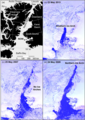 | 1,497 × 2,105 (12.02 MB) | imagescommonswiki>Chhandama | Uploaded a work by Vincent, R.F. from A Study of the North Water Polynya Ice Arch using Four Decades of Satellite Data. Scientific Reports volume 9, Article number: 20278 (2019) https://doi.org/10.1038/s41598-019-56780-6 with UploadWizard |
File usage
The following file is a duplicate of this file (more details):
- File:Last Ice Area NOW.tif from Wikimedia Commons
The following page uses this file:

