File:PANORAMA, FROM ULAKTA HEAD COMMAND POST TO THE WEST TOWARDS MOUNT BALLYHOO - Naval Operating Base Dutch Harbor and Fort Mears, Ulakta Head Fixed Defense Battery Command Post No. 1, Unalaska, Aleutian HABS AK,1-UNAK,2-V-4 (CT).tif
From HandWiki

Size of this preview of this TIF file: 800 × 586 pixels. Other resolution: 640 × 469 pixels.
Original file (4,956 × 3,630 pixels, file size: 51.48 MB, MIME type: image/tiff)
Summary
| PANORAMA, FROM ULAKTA HEAD COMMAND POST TO THE WEST TOWARDS MOUNT BALLYHOO - Naval Operating Base Dutch Harbor and Fort Mears, Ulakta Head Fixed Defense Battery Command Post No. 1, Unalaska, Aleutian Islands, AK | ||||
|---|---|---|---|---|
| Title |
PANORAMA, FROM ULAKTA HEAD COMMAND POST TO THE WEST TOWARDS MOUNT BALLYHOO - Naval Operating Base Dutch Harbor and Fort Mears, Ulakta Head Fixed Defense Battery Command Post No. 1, Unalaska, Aleutian Islands, AK |
|||
| Medium | 5 x 7 in. | |||
| Current location |
Library of Congress Prints and Photographs Division Washington, D.C. 20540 USA http://hdl.loc.gov/loc.pnp/pp.print |
|||
| Accession number |
HABS AK,1-UNAK,2-V-4 (CT) |
|||
| Place of creation | Alaska; Aleutian Islands; Unalaska | |||
| Credit line |
|
|||
| Source/Photographer | https://www.loc.gov/pictures/item/ak0161.color.571880c | |||
| Permission (Reusing this file) |
|
|||

| Camera location | | View this and other nearby images on: OpenStreetMap |
|---|
File history
Click on a date/time to view the file as it appeared at that time.
| Date/Time | Thumbnail | Dimensions | User | Comment | |
|---|---|---|---|---|---|
| current | 21:55, 24 June 2014 | 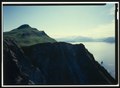 | 4,956 × 3,630 (51.48 MB) | imagescommonswiki>Fæ | GWToolset: Creating mediafile for Fæ. HABS batch uploads start 24 June 2014 |
File usage
The following file is a duplicate of this file (more details):
The following page uses this file:

