File:Thomas Gadsden Tract.pdf
From HandWiki

Size of this JPG preview of this PDF file: 800 × 591 pixels. Other resolution: 640 × 473 pixels.
Original file (7,731 × 5,714 pixels, file size: 10.67 MB, MIME type: application/pdf)
Summary
| Description |
English: Thomas Gadsden had a large tract of his land subdivided for sale to raise funds to satisfy debts. Gadsden Creek is to the west, and Cannon Street is the southern edge of the plat. In this view, west is to the bottom, and east is to the top. |
| Date | |
| Source | Plat book A, page 168 of the Charleston County, South Carolina Deeds Office |
| Author | Robert K. Payne |
Licensing
This work is in the public domain in the United States because it was published (or registered with the U.S. Copyright Office) before January 1, 1929.
Public domain works must be out of copyright in both the United States and in the source country of the work in order to be hosted on the Commons. If the work is not a U.S. work, the file must have an additional copyright tag indicating the copyright status in the source country.
Note: This tag should not be used for sound recordings. |
File history
Click on a date/time to view the file as it appeared at that time.
| Date/Time | Thumbnail | Dimensions | User | Comment | |
|---|---|---|---|---|---|
| current | 11:17, 9 August 2020 | 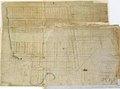 | 7,731 × 5,714 (10.67 MB) | imagescommonswiki>ProfReader | Uploaded a work by Robert K. Payne from Plat book A, page 168 of the Charleston County, South Carolina Deeds Office with UploadWizard |
File usage
The following file is a duplicate of this file (more details):
- File:Thomas Gadsden Tract.pdf from Wikimedia Commons
The following page uses this file:

