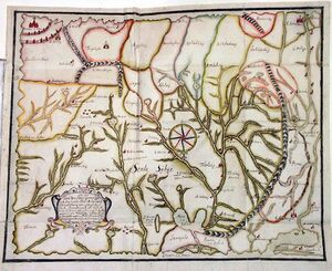
History:Godunov map
From HandWiki
Short description: 1667 ethnographic map of Siberia

The Godunov map was an ethnographic map of Siberia commissioned by Alexis of Russia on 15 November 1667.[1] The original is no longer extant, but two copies were made: one by Claes Johansson Prytz and the other by Fritz Cronman.[2][3] It is named after Petr Ivanovich Godunov the governor (voivode) of Tobolsk.[1][4][5]
References
- ↑ 1.0 1.1 Imago mundi. International Society for the History of Cartography. 1958. https://books.google.com/books?id=2zZCAAAAIAAJ&q=%22Petr+Godunov%22&pg=PA100. "On the 15th of November 1667 the Tsar Alexey Mikhailovitch gave order to the Governor of Tobolsk, Petr Godunov, and his comrades to make a map with the ..."
- ↑ Isis. 4. History of Science Society, Académie internationale d'histoire des sciences. 1922. https://books.google.com/books?id=Dp6ibHxQKmsC&q=%22Fritz+Cronman%22. "A copy made by the Swedish envoy to Russia, Fritz Cronman (or Kroneman) in 1669, is reproduced. ...".
- ↑ Laura Hostetler (15 May 2001). Qing colonial enterprise: ethnography and cartography in early modern China. ISBN 9780226354200. https://books.google.com/books?id=msli1mMua-8C&q=%22Fritz+Cronman%22&pg=PA72. "... The other was made by Fritz Cronman."
- ↑ The equivalent of a governor
- ↑ Nicholas B. Breyfogle, Abby M. Schrader, and Willard Sunderland (2007). Peopling the Russian periphery: borderland colonization in Eurasian history. ISBN 978-0-415-41880-5. https://books.google.com/books?id=uJwH3ofF8BgC&q=%22Godunov+map%22&pg=PA29. "The first surviving map of all of Siberia, the so-called Godunov map of 1667 (named after a Siberian governor, not the tsar), divides the territory with ..."
ru:Фёдор II Годунов#Карта России
 |
