History:Stenehed
From HandWiki

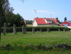
Stenehed is an Iron Age grave field (Steneheds gravfält) located about 1 km southwest of Hällevadsholm, Munkedal Municipality, Västra Götaland County, Sweden. The area contains about 45 graves, a stone circle, a stone ship, and a row of menhirs. [1][2]
Originally, there were eleven or twelve menhirs at the site; today, there are nine. The tallest one is 3.3 m; the shortest - 1.4 m.[3] They are placed in a row, according to their heights. In 1980, Swedish astronomer Curt Roslund (1930-2013) suggested that they form an astronomical calendar, similar to Stonehenge in England.[4]
References
- ↑ "Stenehed Hällevadsholm". https://www.vastsverige.com/en/munkedal/produkter/stenehed/.
- ↑ "Stenehed, the Swedish Stonehenge". https://www.hunebednieuwscafe.nl/2020/06/stenehed-the-swedish-stonehenge/.
- ↑ "Järnålder i Stenehed". Munkedal Municipality. http://www.sotenas.se/kultur/kulturarv/forntid/jarnalderistenehed.4.23a44ef311329f04b9d80007531.html. Retrieved 2010-12-31.
- ↑ "Stenehed. Bohusläns eget Stonehenge.". Bohusläns Museum. http://www9.vgregion.se/vastarvet/bm/up/bohuskarta/detalj1.asp?ID=44. Retrieved 2010-12-31.
[ ⚑ ] 58°34′38″N 11°31′0″E / 58.57722°N 11.516667°E
| Wikimedia Commons has media related to Category:Steneheds gravfält. |
 |
