Place:Bir Gandus
Bir Gandus بئر كندوز Bir Ganduz | |
|---|---|
| Coordinates: [ ⚑ ] 21°37′N 16°28′W / 21.617°N 16.467°W | |
| Territory | Western Sahara |
| Claimed by | |
| Controlled and occupied by | Morocco |
| Area | |
| • Total | 2,186.44 km2 (844.193 sq mi) |
| Population (2014)[1] | |
| • Total | 4,625 |
| • Density | 2.1/km2 (5.5/sq mi) |
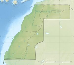
Bir Gandus or Bir Gandouz (Arabic: بئر كندوز Script error: The function "transl" does not exist., Moroccan Arabic: بير گندوز, Berber: Bir Genduz, Spanish: Bir Ganduz) is a village in Western Sahara, currently occupied by Morocco.[2][3] As a claimed rural commune of Morocco it serves as the headquarters of Morocco's Aousserd Province and recorded a population of 4625 in the 2014 Moroccan census.[1] It holds a Moroccan military post.[4] Although sometimes called so, it is not a border post. The border post to Mauritania is to the west on the RN1 at Guerguerat although the stamp given there bore the name of Bir Gandus.[5]
In February 2023, the Royal Moroccan Football Federation announced the construction of two football fields in Bir Gandouz and Guerguerat.[6][7]
References
- ↑ 1.0 1.1 "Population légale des régions, provinces, préfectures, municipalités, arrondissements et communes du royaume d’après les résultats du RGPH 2014" (in ar, fr). High Commission for Planning, Morocco. 8 April 2015. http://rgph2014.hcp.ma/file/166326/. Retrieved 29 September 2017.
- ↑ "A/RES/35/19 - E - A/RES/35/19". p. 214. https://undocs.org/en/A/RES/35/19.
- ↑ Christian Walter; Antje von Ungern-Sternberg; Kavus Abushov (5 June 2014). Self-Determination and Secession in International Law. OUP Oxford. p. 264. ISBN 978-0-19-100692-0. https://books.google.com/books?id=tGQJBAAAQBAJ&pg=PT264.
- ↑ "Bir Gandus, Western Sahara Page", Falling Rain Genomics
- ↑ "transafrika.org" (in de). http://www.transafrika.org/pages/laenderinfo-afrika/mauretanien/grenze-mauretanien--marokko.php. Retrieved 4 January 2019.
- ↑ "Infrastructures : Le lancement des travaux d’aménagement des terrains de Bir Gandouz et Guergearat" (in fr-FR). https://site.frmf.ma/fr/%d8%a5%d8%b7%d9%84%d8%a7%d9%82-%d8%a3%d8%b4%d8%ba%d8%a7%d9%84-%d8%aa%d9%87%d9%8a%d8%a6%d8%a9-%d9%85%d9%84%d8%b9%d8%a8%d9%8a-%d8%a7%d9%84%d9%83%d8%b1%d9%83%d8%b1%d8%a7%d8%aa-%d9%88%d8%a8%d8%a6%d8%b1/.
- ↑ "La FRMF va aménager des terrains à Guergarate et Bir Gandouz" (in fr). 2023-02-23. https://www.leconomiste.com/flash-infos/la-frmf-amenage-des-terrains-de-foot-guergarate-et-bir-gandouz.
External links
[ ⚑ ] 21°37′N 16°28′W / 21.617°N 16.467°W
 |


