Place:City of San Marino
City of San Marino Città di San Marino | |
|---|---|
Capital city and castello | |
Clockwise from top: view of Monte Titano, the aerial cable car, San Marino Cathedral, Via Basilicus, panorama from the top, De La Fratta Tower, Guaita Tower, Palazzo Pubblico | |
 Flag  Coat of arms | |
.svg) San Marino's location in San Marino | |
 City of San Marino San Marino's location in San Marino  City of San Marino City of San Marino (Europe) | |
| Coordinates: [ ⚑ ] 43°56′4.56″N 12°26′50.28″E / 43.9346°N 12.4473°E | |
| Country | |
| Foundation | 3 September 301 (traditional date) |
| Government | |
| • Capitano | Tomaso Rossini (since 2018) |
| Area | |
| • Total | 7.09 km2 (2.74 sq mi) |
| Elevation | 749 m (2,457 ft) |
| Population (January 2022) | |
| • Total | 4,061[1] |
| • Density | 582.23/km2 (1,508.0/sq mi) |
| Time zone | UTC+1 (CET) |
| • Summer (DST) | UTC+2 (CEST) |
| Postal code | RSM-47890 |
| Climate | Cfb |


| UNESCO World Heritage Site | |
|---|---|
 Monte Titano and three fortresses on top of it can be seen from many kilometers away | |
| Criteria | Cultural: iii |
| Reference | 1245 |
| Inscription | 2008 (32nd session) |
| Area | 55 ha |
| Buffer zone | 167 ha |
The City of San Marino (Italian: Città di San Marino), also known simply as San Marino and locally as Città, is the capital city of the Republic of San Marino. It has a population of 4,061.[1] It is on the western slopes of San Marino's highest point, Monte Titano.
Geography
It is the third largest city in the country, after Dogana and Borgo Maggiore. It borders the San Marino municipalities Acquaviva, Borgo Maggiore, Fiorentino, and Chiesanuova and the Italian municipality San Leo.
Akademio Internacia de la Sciencoj San Marino was centered here.
History
The city is claimed to be founded by Saint Marinus and several Christian refugees fleeing from Roman persecution in the year 301.
The urban heart of the city was protected by three towers: the first, Guaita, built in the 11th century, held a reputation for being impenetrable which to a great extent discouraged attacks.
Tensions with bordering powers urged the necessity to build a second tower, Cesta (13th century). The defensive system was not completed until the construction of a third tower, the Montale (14th century) - the smallest of all and constructed on the last of the summits of Monte Titano.
With the population of the city increasing, the territory of the country was extended by a few square kilometers. Since the Sammarinese policy was not to invade or to use war to obtain new territories, it was by means of purchases and treaties that San Marino obtained the other eight castelli which make up the country.
Parishes
The City of San Marino has the following 7 parishes or wards (curazie):[2]
- Cà Berlone
- Canepa
- Casole
- Castellaro
- Montalbo
- Murata
- Santa Mustiola
Economy
The economy of the city of San Marino has always been closely bound to that of the country. Until recently, the main economic activities of the locality were stone extraction and carving. Today, there is a more varied economy, including tourism, commerce, sale of postage stamps, and a small agricultural industry, although the latter is in decline.
Landmarks

The city is visited by more than three million people per year, and has developed progressively as a tourist centre. Of the tourists, 85% are Italian. There are also more than a thousand retail outlets, where one can find a great variety of products.
Main sights
- Basilica di San Marino
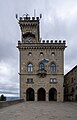
- Palazzo dei Capitani
- Palazzo Pubblico
- Teatro Titano
- The Three Towers of San Marino
- Piazza del Titano
- Piazza Garibaldi
- Monastery of Santa Clara
- Grand Hotel San Marino
Transport
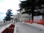
- The city is known for its long, winding cobblestoned streets, as its altitude and steep approach put it beyond the reach of the San Marino Highway. San Marino is also notable in that cars are prohibited in much of the city center. A series of lifts connects the upper part of city with the lower.
City of San Marino is the top terminus of the Funivia di San Marino, an aerial cablecar system that connects the city to Borgo Maggiore.[3] Running every fifteen minutes, the two-minute ride is renowned for its paronamic views over San Marino, the Province of Rimini, and the Adriatic Sea.[3][4] The City of San Marino terminus is located at the turn of Contrada Omagnano with Contrada del Pianello, at the historic city centre's northern end, next to the Tourism Secretariat and less than 200 metres (660 feet) from the Basilica of San Marino and the Piazza della Libertà.[5]
The City of San Marino is the terminus of seven of San Marino's eight bus lines, which run to other settlements in the country.[6] Additionally, the central bus stop in Piazzale Marino Calcigni is the terminus of a regular coach connection to Rimini,[7][8] operated by coach companies Bonelli and Benedettini.[7]
Between 1932 and 1944, a 31.5-kilometre (19.6-mile) electrified narrow gauge railway operated between Rimini and the City of San Marino.[9] During the Second World War, the line was bombed and closed,[9][10] after which its tunnels sheltered refugees during the Battles of Rimini and San Marino.[11][12] After the war, the railway was abandoned in favour of the San Marino Highway.[12][13]
In 2012, an 800-metre (1⁄2-mile) section was reopened as a heritage railway in the City of San Marino, running between Piazzale della Stazione and near Via Napoleone.[14] The restored section comprises the original railway's final horseshoe turn through the 502-metre (1,647-foot) Montale tunnel.[15][16]
Sport
The city of San Marino has three football teams: the S.S. Murata, the S.P. Tre Penne and the San Marino Academy. The city had the Olympic Flame pass through San Marino during the run-up to the 2006 Winter Olympics.
International relations
City of San Marino is twinned with:
Gallery
Palazzo Pubblico,
the City Hall
Guaita tower

Cesta tower

Montale tower
Via Paul III

Statue of Liberty in the square of the City Hall

Panoramic view from Murata
.jpg)


See also
- Carcere dei Cappuccini, the only prison in San Marino
References
- ↑ 1.0 1.1 "Resident Population per municipality". Office of Economic Planning, Data Processing and Statistics. https://www.statistica.sm/on-line/en/home/statistics/population.html?Categoria=2&nodo=/on-line/en/home/statistics/population/demographic-structure.html.
- ↑ "Article with the list of curazie on the official Sanmarinese electoral website". http://www.elezioni.sm/index.php?id=299.
- ↑ 3.0 3.1 "Ropeway – San Marino Cable Car". https://www.sanmarinosite.com/en/how-to-reach/ropeway/.
- ↑ "Funivia di San Marino" (in it-SM). https://www.doppelmayr.com/it/progetti-di-riferimento/progetto-di-riferimento-45-atw-funivia-di-san-marino/.
- ↑ "Pianta della Città di San Marino" (in it-SM). https://www.sanmarinosite.com/sms_pdf/centro_storico.pdf.
- ↑ "Orari autobus di linea" (in it-SM). https://www.aass.sm/site/home/trasporti/orari-autobus-di-linea.html.
- ↑ 7.0 7.1 "Bus to San Marino Republic". 17 July 2023. https://riminiturismo.it/en/visitatori/come-arrivare/collegamenti/pullman/bus-san-marino-republic.
- ↑ "Pianta della Città di San Marino" (in it-SM). https://www.sanmarinosite.com/sms_pdf/centro_storico.pdf.
- ↑ 9.0 9.1 Macina, Chiara (14 September 2015). "Il Trenino Biancazzurro: la breve vita e la fine" (in it-IT). https://www.zoomma.news/il-trenino-biancazzurro-la-breve-vita-e-la-fine/.
- ↑ Giardi, Davide (28 February 2013). "Breve storia della Ferrovia" (in it-SM). https://www.libertas.sm/breve-storia-della-ferrovia/.
- ↑ Pagammo, Lussi (20 April 2019). "Il glorioso trenino bianco-azzurro riparte dall'elettromotrice 'AB-03' per unire Rimini a San Marino" (in it-IT). https://www.riminiduepuntozero.it/il-glorioso-trenino-bianco-azzurro-riparte-dallelettromotrice-ab-03-per-unire-rimini-a-san-marino/.
- ↑ 12.0 12.1 "12 giugno 1932 - Viene inaugurata la ferrovia Rimini - San Marino" (in it-IT). 12 June 2023. https://www.chiamamicitta.it/12-giugno-1932-viene-inaugurata-la-ferrovia-rimini-san-marino/.
- ↑ Giuliani-Balestrino, Maria Clotilde (2005). "La superstrada Rimini-San Marino" (in it-IT). Studi e Ricerche di Geografia 29 (1): 1–4. https://studiericerche.org/wp-content/uploads/2020/07/Giuliani-Balestrino-1-4.pdf.
- ↑ Scolari, Giancarlo (21 June 2012). "Torna il treno a San Marino" (in it-IT). https://www.ferrovie.it/portale/articoli/3190.
- ↑ Vilmos, Oszter (12 August 2012). "Kis ország, kis( )vasút" (in hu). https://iho.hu/hirek/kis-orszag-kis-vasut-120812.
- ↑ "Galleria 'Montale': ex-ferrovia Rimini-San Marino" (in it-IT). https://www.sdaprogetti.it/it-IT/progetto/galleria.
- ↑ "Celebrazioni nel 50° del gemellaggio con Arbe" (in it). https://www.esteri.sm/pub1/EsteriSM/dettaglio_notizia.html?idItem=65af2a38-f077-40e0-aab2-6d5eb7dc0484.
- ↑ "San Leo e Città di San Marino: il gemellaggio compie 20 anni" (in it). https://www.sanmarinortv.sm/news/attualita-c4/san-leo-citta-san-marino-gemellaggio-compie-20-a59376.
- ↑ "gemellaggio nanjing - San Marino" (in it). https://www.sanmarinortv.sm/news/attualita-c4/giunta-di-castello-di-citta-e-contea-di-nanjing-siglato-gemellaggio-a200459.
External links
- (in Italian) San Marino's page on giuntedicastello.sm
[ ⚑ ] 43°56′4.56″N 12°26′50.28″E / 43.9346°N 12.4473°E
 |  |

