Place:Hjuksevelta
From HandWiki
Short description: Village in Notodden, Norway
Hjuksevelta Hjukse | |
|---|---|
Village | |
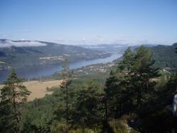
 View of the village area, looking towards Notodden | |
| Lua error in Module:Location_map at line 522: Unable to find the specified location map definition: "Module:Location map/data/Vestfold og Telemark" does not exist. | |
| Coordinates: [ ⚑ ] : 59°30′32″N 9°19′15″E / 59.50875°N 9.3209°E | |
| Country | Norway |
| Region | Eastern Norway |
| County | Vestfold og Telemark |
| District | Aust-Telemark |
| Municipality | Notodden Municipality |
| Area | |
| • Total | 0.35 km2 (0.14 sq mi) |
| Elevation | 25 m (82 ft) |
| Population (2022)[1] | |
| • Total | 271 |
| • Density | 765/km2 (1,980/sq mi) |
| Time zone | UTC+01:00 (CET) |
| • Summer (DST) | UTC+02:00 (CEST) |
| Post Code | 3683 Notodden |
Hjuksevelta or simply Hjukse is a village in Notodden Municipality in Vestfold og Telemark county, Norway . The village is located about half-way between the town of Notodden and the village of Nordagutu (in Midt-Telemark Municipality. The village is located on the hills overlooking the eastern shore of the lake Heddalsvatnet. In 2020, the Hjuksebø area became part of Notodden Municipality. Prior to that time, it was part of the old Sauherad Municipality.[3]
The 0.35-square-kilometre (86-acre) village has a population (2022) of 271 and a population density of 765 inhabitants per square kilometre (1,980/sq mi).[1]
The village of Hjuksebø and the old Hjuksebø Station are located just south of this village.[3]
References
- ↑ 1.0 1.1 1.2 Statistisk sentralbyrå (2022-01-01). "Urban settlements. Population and area, by municipality". https://www.ssb.no/en/befolkning/statistikker/beftett/aar.
- ↑ "Hjuksevelta, Notodden". yr.no. https://www.yr.no/nb/v%C3%A6rvarsel/daglig-tabell/1-57937/Norge/Vestfold%20og%20Telemark/Notodden/Hjuksevelta. Retrieved 2023-08-26.
- ↑ 3.0 3.1 Lundbo, Sten, ed (2022-12-28). "Hjuksevelta" (in Norwegian). Store norske leksikon. Kunnskapsforlaget. https://snl.no/Hjuksevelta. Retrieved 2023-08-26.
 |

