Place:Kattendijke
Kattendijke | |
|---|---|
Village | |
 View on Kattendijke | |
 Coat of arms | |
 Kattendijke Location in the province of Zeeland in the Netherlands  Kattendijke Kattendijke (Netherlands) | |
| Coordinates: [ ⚑ ] : 51°31′22″N 3°56′36″E / 51.52278°N 3.94333°E | |
| Country | Netherlands |
| Province | Zeeland |
| Municipality | Goes |
| Area | |
| • Total | 5.11 km2 (1.97 sq mi) |
| Elevation | −0.3 m (−1.0 ft) |
| Population (2021)[1] | |
| • Total | 530 |
| • Density | 100/km2 (270/sq mi) |
| Time zone | UTC+1 (CET) |
| • Summer (DST) | UTC+2 (CEST) |
| Postal code | 4474[1] |
| Dialing code | 0113 |
Kattendijke is a village in the Dutch province of Zeeland. It is located in the municipality of Goes on the Oosterschelde about 5 km northeast of the city of Goes.
History
The village was first mentioned in 1214 as Cattindic. The etymology is unclear.[3] The flood of 1134 resulted in large inundated areas around Kattendijke. The Cistercians monks from abbey Ter Doel started to build dikes and polder the land. Kattendijke developed into a heerlijkheid.[4]
The Dutch Reformed church was built in 1404 on a terp (artificial hill). Only the nave of the medieval church remains due to war and decay. It was renovated in 1954 and restored to its original shape.[4]
Kattendijke was home to 255 people in 1840.[5] In 1927, a railway station was built on the Goes to Wemeldinge railway line. The station closed in 1934.[6]
Until 1970, Kattendijke was a separate municipality when it was merged into Goes.[7] The municipality also covered the village of Wilhelminadorp which contained the town hall.[5]
Gallery
-
 Dutch Reformed church
 -
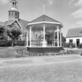 Bandstand


References
- ↑ 1.0 1.1 1.2 "Kerncijfers wijken en buurten 2021". https://www.cbs.nl/-/media/_excel/2021/48/kwb-2021.xls.
- ↑ "Postcodetool for 4474AA" (in nl). Actueel Hoogtebestand Nederland. Het Waterschapshuis. 24 July 2019. http://www.ahn.nl/postcodetool.
- ↑ "Kattendijke - (geografische naam)" (in nl). https://etymologiebank.nl/trefwoord/kattendijke.
- ↑ 4.0 4.1 "Kattendijke" (in nl). 7 February 2016. https://www.zalig-zeeland.com/agenda_archief/kattendijke.
- ↑ 5.0 5.1 "Kattendijke" (in nl). https://www.plaatsengids.nl/kattendijke.
- ↑ "station Kattendijke" (in nl). http://stationsweb.nl/station.asp?station=kattendijke&vraag=kattendijke.
- ↑ Ad van der Meer and Onno Boonstra, "Repertorium van Nederlandse gemeenten", KNAW, 2006. "KNAW > Publicaties > Detailpagina". http://www.knaw.nl/cfdata/publicaties/detail.cfm?boeken__ordernr%3D20061061.
 |
