Place:Laatokan Karjala
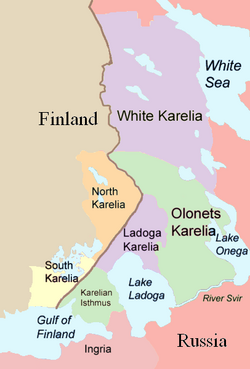
Laatokan Karjala ('Ladoga Karelia') is a historical region of Karelia, currently largely in Russia. Today the term can also refer to the part of the Republic of Karelia in the Russian Federation known as Russian: Ладожская Карелия, romanized: Ladožskaja Karelija, Russian: Карельское Приладожье, romanized: Karelskoje Priladožje or Russian: Северное Приладожье, romanized: Severnoje Priladožje and comprising the south-west part of the Republic, specifically Lakhdenpokhsky District, Pitkyarantsky District and Sortavala District. This region is on the northern littoral of Lake Ladoga, which borders Olonetsky District to the East, Leningrad Oblast to the south-west and the North Karelia region of Finland to the west.[1][2]
History
When state formation first began in the region, Laatokan Karjala belonged to the Novgorod Republic; thereafter it came under Russian rule, as part of Kexholm County. Along with Kexholm County, Laatokan Karjala was transferred to Sweden through the Treaty of Stolbovo in 1617. Sweden lost Laatokan Karjala to Russia in the Treaty of Nystad in 1721, after which the area became part of the Viborg Governorate, also known as Old Finland. Following the Russian conquest of the rest of Finland, this so-called "Old Finland" was united, under the name Viborg Province, with the newly constituted Grand Duchy of Finland in 1812. The Laatoka Karjala area of Finland was divided into Central Karelia and Border Karelia.[3][4] The area remained part of Finland following its independence from Russia in 1917.[citation needed]
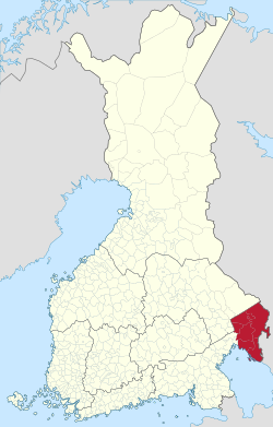
Laatokan Karjala was fought over by Finland and the Soviet Union during the 1939–40 Winter War (ended by the Moscow Peace Treaty) and the 1941–44 Continuation War. Following these conflicts, only small parts of Laatokan Karjala remained in Finland. Some form part of the South Karelia region: the Finnish parts of Parikkala, Saari and Uukuniemi municipalities are now part of Parikkala municipality; the former Simpelee municipality is part of the current Rautjärvi municipality. Meanwhile, Kolkka, the westernmost part of the former Korpiselä municipality that remained in Finland, was joined to Tuupovaara municipality, which in turn is now part of Joensuu and North Karelia province.[citation needed]
Keski-Karjala (Central Karelia)
The historic region of Central Karelia was divided into the following municipalities and hundreds (kihlakunnat):
- Harlu (Sortavalan kihlakunta)
- Jaakkima (Kurkijoen kihlakunta)
- Kurkijoki (Kurkijoen kihlakunta)
- Lahdenpohja (Kurkijoen kihlakunta)
- Lumivaara (Kurkijoen kihlakunta)
- Parikkala (Kurkijoen kihlakunta)
- Ruskeala (Sortavalan kihlakunta)
- Saari (Kurkijoen kihlakunta)
- Simpele (Kurkijoen kihlakunta)
- Sortavala
- Sortavalan maalaiskunta, including Valamo (Sortavalan kihlakunta)
- Uukuniemi (Sortavalan kihlakunta)
Hiitola was also sometimes read as belonging to Laatoka Karjala. Pälkjärvi belonged to the parish of Ilomantsi and thus to the county of Kuopio. Because of its geographical position and historical background, however, it could also be connected to Laatokan Karjala.[5]
Raja-Karjala (Border Karelia)
Raja-Karjalassa puhuttiin yleisesti karjalan kielen eri murteita ja merkittävä osa väestöstä oli uskonnoltaan ortodokseja.
The historic region of Border Karelia was divided into the following municipalities (all belonging to Salmin kihlakunta):
- Impilahti
- Korpiselkä
- Salmi
- Soanlahti
- Suistamo
- Suojärvi
Further reading
- Водопады Северного Приладожья Диагональный мир (in Russian)
References
- ↑ Северное Приладожье Карелия культурный туризм (in Russian).
- ↑ Northern Priladozhje Karelia cultural tourism.
- ↑ "Kartasto – Nykyinen Karjalan tasavalta ja Laatokan Karjalan alueet". Säätiö Väinölä, www.saatiovainola.fi. April 29, 2013. http://www.saatiovainola.fi/kartasto/.
- ↑ Ahola V, Kuhlman I. ja Luotio J. (toim.) (1999). Tietojätti 2000. Helsinki: Gummerus. p. 443. ISBN 951-20-5809-X.
- ↑ Luovutettu Karjala, Pitäjät: Pälkjärvi


