Place:Lubenice
Lubenice Lubenizze | |
|---|---|
Village | |
 View of Lubenice | |
 Lubenice | |
| Coordinates: [ ⚑ ] : 44°53′16″N 14°19′54″E / 44.88784°N 14.33160°E | |
| Country | |
| County | |
| Town | Cres |
| Area | |
| • Total | 7.8 km2 (3.0 sq mi) |
| Population (2021)[2] | |
| • Total | 6 |
| • Density | 0.77/km2 (2.0/sq mi) |
| Time zone | UTC+1 (CET) |
| • Summer (DST) | UTC+2 (CEST) |
| Postal code | 51557 |
| Area code(s) | 051 |
| Vehicle registration | RI |
Lubenice (Template:IPA-hr, Italian: Lubenizze) is an ancient fort city on the Croatian island of Cres that was founded approximately four thousand years ago on top of a 380 m high ridge that overlooks the Adriatic Sea.[3] It is a small local center that comprises forty buildings and six permanent inhabitants.[4][2] Buildings in the city are mainly constructed out of the same material as the surrounding cliffs, a lesser part dates back to a former settlement of ancient Romans.[5] There are two well-preserved extant city gates on the north and south of the city as well a wall in the east. The church in the fort is devoted to the Visitation of the Blessed Virgin Mary (Croatian: Crkva Pohođenja Blažene Djevice Marije).
It was nominated to be a UNESCO World Heritage site in 2005.[4]
Gallery
-
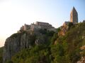 View of Lubenice
 -
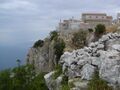 View of Lubenice
 -
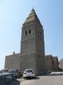 Lubenice belltower
 -
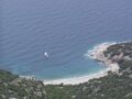 Lubenice beach


See also
- Tentative list of World Heritage Sites in Croatia
Notes and references
- ↑ Wikidata Q119585703
- ↑ 2.0 2.1 Template:Croatian Census 2021
- ↑ Barbir, F. & Ulgiati, S. (2008), Sustainable Energy Production and Consumption: Benefits, Springer, ISBN 1-4020-8493-5
- ↑ 4.0 4.1 Lubenice - UNESCO World Heritage Centre
- ↑ Das Dorf Lubenice auf der nordkroatischen Insel Cres. Marcel Meier, ETH Zürich, 1997, 2015.10.31 called
Bibliography
- Barbir, F. & Ulgiati, S. (2008), Sustainable Energy Production and Consumption: Benefits, Springer, ISBN 1-4020-8493-5
External links
 |

