Place:Yli
From HandWiki
Short description: Village in Notodden, Norway
Yli | |
|---|---|
Village | |
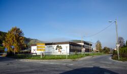
 View of the village school which closed in 2014 | |
| Lua error in Module:Location_map at line 522: Unable to find the specified location map definition: "Module:Location map/data/Vestfold og Telemark" does not exist. | |
| Coordinates: [ ⚑ ] : 59°33′21″N 9°12′05″E / 59.5557°N 9.20136°E | |
| Country | Norway |
| Region | Eastern Norway |
| County | Vestfold og Telemark |
| District | Aust-Telemark |
| Municipality | Notodden Municipality |
| Area | |
| • Total | 0.24 km2 (0.09 sq mi) |
| Elevation | 88 m (289 ft) |
| Population (2022)[1] | |
| • Total | 291 |
| • Density | 1,198/km2 (3,100/sq mi) |
| Time zone | UTC+01:00 (CET) |
| • Summer (DST) | UTC+02:00 (CEST) |
| Post Code | 3677 Notodden |
Yli is a village in Notodden Municipality in Vestfold og Telemark county, Norway . The village is located about 5 kilometres (3.1 mi) to the west of the town of Notodden and about 3 kilometres (1.9 mi) to the southeast of the village of Heddal. The river Heddøla flows past the village just before emptying into the lake Heddalsvatnet about 1.5 kilometres (0.93 mi) east of the village.[3]
The 0.24-square-kilometre (59-acre) village has a population (2022) of 291 and a population density of 1,198 inhabitants per square kilometre (3,100/sq mi).[1]
Notodden Airport and the European route E134 highway are both located just north of the village.[3]
References
- ↑ 1.0 1.1 1.2 Statistisk sentralbyrå (2022-01-01). "Urban settlements. Population and area, by municipality". https://www.ssb.no/en/befolkning/statistikker/beftett/aar.
- ↑ "Yli, Notodden". yr.no. https://www.yr.no/nb/v%C3%A6rvarsel/daglig-tabell/1-57090/Norge/Vestfold%20og%20Telemark/Notodden/Yli.
- ↑ 3.0 3.1 Lundbo, Sten, ed (2022-12-28). "Yli" (in no). Store norske leksikon. Kunnskapsforlaget. https://snl.no/Yli. Retrieved 2023-08-26.
 |
