Place:Zagora, Morocco
Zagora زاكورة | |
|---|---|
    | |
 Zagora Location in Morocco  Zagora Zagora (Africa) | |
| Coordinates: [ ⚑ ] : 30°19′50″N 5°50′17″W / 30.33056°N 5.83806°W | |
| Country | |
| Region | Drâa-Tafilalet |
| Province | Zagora |
| Population (2004) | |
| • Total | 34,851 |
| Time zone | UTC+0 (WET) |
| • Summer (DST) | UTC+1 (WEST) |
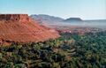
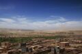
Zagora (Arabic: زاكورة) is a town located in the Draa River valley in the Moroccan region of Drâa-Tafilalet.
On the base of the Zagora Mountain the remains of an Almoravid fortress can still be seen.[1] The exact location of the former Almoravid mosque is still a matter of dispute. Each year the moussem (festival) of the Sufi saint Moulay Abdelkader Jilali is celebrated at Zagora.
Languages spoken in the city include Moroccan Arabic, Tachelhit and Tamazight.
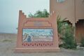
A sign at the town border states "Tombouctou 52 days", the supposed time it takes to get to Timbuktu, Mali on foot or camel. The original sign has been replaced by a mural painting.[2]
Climate
Zagora has a hot desert climate (Köppen climate classification BWh). Script error: No such module "weather box".
Culture
Zagora is also noted for international events such as the Zagora Marathon and the Nomads Festival in M'Hamid.
Local institutions
The weekly outdoor market (souk) is held on Sunday in the city center.[3]
Features
-
-
-
-
-
 Military castle

.jpg)

References
- ↑ Allain (Ch) & Meunie (J.), "La forteresse almoravide de Zagora", Hespéris, 1956, vol. xliii, fasc. 2, pp. 305–325.
- ↑ blog.travel-exploration.com Travel-blog with picture of the old and new sign. Sitat: The town has recently had a new “52 Days to Timbuktu “ sign painted and posted however the old one still remains.
- ↑ List of weekly open-air markets in the province of Zagora
External links
 |  |
