Religion:Kankali Tila
Jaini Mound | |
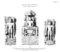
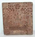
 Location of Kankali Tila in Mathura.  Ayagapatta, Jain Tablet of homage (Circa 1st Century CE) excavated from Kankali Mound (Photo:Government Museum, Mathura) | |
| Lua error in Module:Location_map at line 422: No value was provided for longitude. |

| <graph>
{ // // ATTENTION: This code is maintained at https://www.mediawiki.org/wiki/Template:Graph:Street_map_with_marks // Please do not modify it anywhere else, as it may get copied and override your changes. // Suggestions can be made at https://www.mediawiki.org/wiki/Template_talk:Graph:Street_map_with_marks // // Template translation is in https://commons.wikimedia.org/wiki/Data:Original/Template:Graphs.tab // "version": 2, "width":270, "height": 200, "padding": 0, "signals":[ // These signals allow us to quickly move the map within the image, e.g. to leave space for the legend {"name":"legendWidth", "init": {"expr": "0"} }, {"name":"legendHeight", "init": {"expr": "height"} },
{"name":"imgWidth", "init": {"expr": "width-legendWidth"} },
{"name":"imgHeight", "init": {"expr": "height"} },
{"name":"imgXC", "init": {"expr": "imgWidth/2"} },
{"name":"imgYC", "init": {"expr": "imgHeight/2"} },
{"name":"imgTileSize", "init": {"expr": "256"} },
{"name":"imgLat", "init": {"expr": "27.491389"} },
{"name":"imgLon", "init": {"expr": "77.673889"} },
{"name":"imgZoom", "init": {"expr": "13"} },
{"name":"picWidth", "init": {"expr": "180"} },
{"name":"picHeight", "init": {"expr": "picWidth/2"} },
{"name":"picXC", "init": {"expr": "imgWidth-(picWidth/2)"} },
{"name":"picYC", "init": {"expr": "imgHeight-(picHeight/2)"} },
{"name":"showMiniMap", "init": {"expr": "0"} }
],
"data": [
{
"name": "data",
// Otherwise use the first unnamed argument for source values "values": [ { "lat": 27.491389,
"lon": 77.673889,
"img": "wikirawupload:https://handwiki.org/wiki/images/thumb/1/10/Mapscaleline.svg/120px-Mapscaleline.svg.png",
"width": 50,
"height": 8,
"offsetX": 98,
"offsetY": 90,
"textAlign": "right",
"textDx": 22,
"textDy": -2,
"textColor": "grey",
"textFont": "Tahoma",
"textFontSize": 9,
"text": "1.5km" }
, { "lat": 0, "lon": 0, "img": "wikirawupload:https://handwiki.org/wiki/images/thumb/0/0c/Red_pog.svg/10px-Red_pog.svg.png", "height": 10, "width": 10, "text": "", "textAngle": 0, "textAlign": "right", "textBaseline": "middle", "textDx": -7, "textDy": 1, "textFontSize": 12, "textColor": "#AA1205"
}
, { "lat": 27.491389, "lon": 77.673889, "img": "wikirawupload:https://handwiki.org/wiki/images/thumb/e/e9/Archaeological_site_icon_%28red%29.svg/12px-Archaeological_site_icon_%28red%29.svg.png", "height": 12, "width": 12, "text": "", "textAngle": 0, "textAlign": "right", "textBaseline": "middle", "textDx": -8, "textDy": 1, "textFontSize": 12, "textColor": "#AA1205"
}
     ],
     "transform": [
       {
         "type": "geo",
         "projection": "mercator",
         "scale": {"expr": "imgTileSize/PI/2*pow(2,imgZoom)"},
         "translate": [{"expr": "imgXC"}, {"expr": "imgYC"}],
         "center": [{"expr": "imgLon"}, {"expr": "imgLat"}],
         "lon": "lon", "lat": "lat"
       },
       { "type": "formula", "field":"layout_x", "expr": "datum.layout_x + (datum.offsetX || 0)" },
       { "type": "formula", "field":"layout_y", "expr": "datum.layout_y + (datum.offsetY || 0)" },
       { "type": "formula", "field":"color", "expr": "datum.color || '#c33'" },
       { "type": "formula", "field":"textColor", "expr": "datum.textColor || datum.color" },
       { "type": "formula", "field":"strokeColor", "expr": "datum.strokeColor || '#ffe7e6'" }
     ]
   },
   {
     // Hack: single value data source for drawing/hiding images and other non-series elements
     "name": "dummyData",
     "values": [{}]
   }
 ],
// Legend only works if showLegend and colorScaleField are set "marks": [
{
"type": "image",
"from": {
"data": "dummyData",
"transform": [
{ "type": "formula", "field":"url", "expr": "'mapsnapshot:///?width='+imgWidth+'&height='+imgHeight+'&zoom='+imgZoom+'&lat='+imgLat+'&lon='+imgLon" }
]
},
"properties": {
"enter": {
"url": {"field": "url"},
"xc": {"signal": "imgXC"}, "yc": {"signal": "imgYC"},
"width": {"signal": "imgWidth"}, "height": {"signal": "imgHeight"}
}
}
},
{
// Places an image of a given name and size at the [lan,lon] location
"type": "image",
"from": {
"data": "data",
"transform": [
{ "type": "filter", "test": "datum.img" },
{ "type": "formula", "field":"iconWidth", "expr": "datum.width || 0" },
{ "type": "formula", "field":"iconHeight", "expr": "datum.height || 0" },
{ "type": "formula", "field":"img",
"expr": "if(!test(/^[a-z]+:\\/\\//, datum.img), 'wikifile:///'+datum.img, datum.img)" },
// Ensure that either width or height parameter is passed to wikifile:// request
{ "type": "formula", "field":"img",
"expr": "if((datum.iconWidth || datum.iconHeight) && !test(/[?&](width|height)=\\d/, datum.img),if(datum.iconWidth,datum.img+'?width='+datum.iconWidth,datum.img+'?height='+datum.iconHeight), datum.img)" }
]},
"properties": {
"enter": {
"url": {"field": "img"},
"xc": {"field": "layout_x"}, "yc": {"field": "layout_y"},
"width": {"field": "iconWidth"}, "height": {"field": "iconHeight"}
}
}
},
{
// Draw marks of a given color, shape, and size at the [lan,lon] location
"type": "symbol",
"from": {
"data": "data",
"transform": [{ "type": "filter", "test": "!datum.img" }]
},
"properties": {
"enter": {
"x": {"field": "layout_x"},
"y": {"field": "layout_y"},
// If colorScaleField is set, use color scaling, otherwise use the preset color value
"fill": { "field": "color" },
"size": {"field": "size"},
"shape": {"field": "shape"},
"stroke": {"field": "strokeColor"}
}
}
},
{
// Draw text with the given color and size at the [lan,lon] location
// See https://github.com/vega/vega/wiki/Marks#text for all parameter description (prepend "text" and capitalize them)
"type": "text",
"from": {
"data": "data",
"transform": [
{ "type": "filter", "test": "datum.text" },
// Figure out if this is an LTR or RTL page. For LTR, show label to the right of the icon, left-aligned. For RTL, reverse.
{ "type": "formula", "field":"isLTR", "expr": "'' == '\\u200E'" },
// If these values are not defined ("undefined" is not allowed, so test for truthiness and not 0)
{ "type": "formula", "field":"textDx", "expr": "if(!datum.textDx && datum.textDx != 0, if(datum.isLTR,8,-8), datum.textDx)" },
{ "type": "formula", "field":"textAlign", "expr": "if(!datum.textAlign, if(datum.isLTR,'left','right'), datum.textAlign)" },
{ "type": "formula", "field":"textBaseline", "expr": "datum.textBaseline || 'middle'" }
]},
"properties": {
"enter": {
"text": {"field": "text"},
"x": {"field": "layout_x" },
"y": {"field": "layout_y"},
"dx": {"field": "textDx" },
"dy": {"field": "textDy"},
"fill": {"field": "textColor"},
"align": {"field": "textAlign"},
"baseline": {"field": "textBaseline"},
"radius": {"field": "textRadius"},
"theta": {"field": "textTheta"},
"angle": {"field": "textAngle"},
"font": {"field": "textFont"},
"fontSize": {"field": "textFontSize"},
"fontWeight": {"field": "textFontWeight"},
"fontStyle": {"field": "textFontStyle"}
}
}
},
{
// Draw a low-zoom locator map frame
"type": "rect",
"from": {
"data": "dummyData",
"transform": [
{ "type": "filter", "test": "showMiniMap" }
]
},
"properties": {
"enter": {
"xc": {"signal": "picXC"}, "yc": {"signal": "picYC"},
"width": {"signal": "picWidth", "offset":2}, "height": {"signal": "picHeight"},
"stroke": {"value":"#fff"},"strokeWidth": {"value":6}
}
}
},
{
// Draw a low-zoom locator map by using a premade world map image
"type": "image",
"from": {
"data": "dummyData",
"transform": [
{ "type": "filter", "test": "showMiniMap" },
{ "type": "formula", "field":"url", "expr": "1" }
]
},
"properties": {
"enter": {
"url": {"value": "wikirawupload:https://handwiki.org/wiki/images/thumb/a/ac/Earthmap1000x500.jpg/180px-Earthmap1000x500.jpg"},
"xc": {"signal": "picXC"}, "yc": {"signal": "picYC"},
"width": {"signal": "picWidth"}, "height": {"signal": "picHeight"}
}
}
},
{
// Draw a zoom-out mark at the [lan,lon] location
"type": "symbol",
"from": {
"data": "dummyData",
"transform": [
{ "type": "filter", "test": "showMiniMap" },
{ "type": "formula", "field":"lat", "expr": "imgLat" },
{ "type": "formula", "field":"lon", "expr": "imgLon" },
{
"type": "geo",
"projection": "equirectangular",
"scale": {"expr": "180/2/PI"},
"translate": [{"expr": "picXC"}, {"expr": "picYC"}],
"center": [{"expr": "0"}, {"expr": "0"}],
"lon": "lon", "lat": "lat"
}
]
},
"properties": {
"enter": {
"x": {"field": "layout_x"}, "y": {"field": "layout_y"},
"fill": {"value": "#c33"},
"stroke": {"value": "#ffe7e6"},
"size": {"value": 40}
}
}
}
]
} </graph> <maplink zoom="14" latitude="27.491389" longitude="77.673889" text="[Interactive fullscreen map]">
[
"features": [
  "properties": {
   "title": ".",
   "description": " 27.491389,77.673889",
   "marker-symbol": "-number", "marker-size": "medium", "marker-color": "#AA1205" },
  "geometry": {"type": "Point", "coordinates": [77.673889,27.491389] }
}
|
Kankali Tila in Mathura
|
Kankali Tila (also Kankali mound or Jaini mound) is a mound located at Mathura in the Indian state of Uttar Pradesh. The name of the mound is derived from a modern temple of Hindu goddess Kankali. The famous Jain stupa was excavated here in 1890-91 by Alois Anton Führer (Dr. Führer).[3]
The mound almost rectangular in shape is 500 feet long by 350 feet broad.[3] Kankali Tila brought forth many treasures of Jain art. The archaeological findings testifies the existence of two Jain temples and stupas. Numerous Jain sculptures, Ayagapattas (tablet of homage),[4] pillars, crossbeams and lintels were found during archaeological excavations. Some of the sculptures are provided with inscriptions that report on the contemporary society and organization of the Jain community.
Most sculptures could be dated from the 2nd century BC to the 12th century CE, thus representing a continuous period of about 14 centuries during which Jainism flourished at Mathura. These sculptures are now housed in the Lucknow State Museum and in the Mathura Museum.
Excavation
.jpg)
Alexander Cunningham worked at the western end in March and November 1871. The objects found by Mr. Cunningham were all Jain, with the exception of one ten-armed Brahmanical figure. Mr. Growse operated on the northern portion in 1875. In Volume XVII of the "Reports" (page 111), Mr. Cunningham noted that in the season of 1881-82 he dug up many Jain figures, including one inscribed with the name of Vardhamana, the last of the 24 Jain Tirthankara.[5] Dr. Burgess and Dr. Fuhrer extended the excavations to the eastern end at different times from 1887 to 1896. Mr. Harding, a predecessor of Mr. Growse as Magistrate of Mathura, also made some excavations. The excavations at Kankali Tila acted as a testimony to the claims made by Jains regarding the great antiquity of their religion.[6]
Significance
The sculptures and the inscriptions found at Kankali Tila suggest that in that period a clear Digambar-Shwetabar division had not risen. The Tirthankar images are all unclothed and monks are represented as not wearing a loincloth, but with cloth on one forearm. The names of divisions of the monastic orders match exactly with those given in the Shwetambar Kalpasutra.[7]
Gallery

1st Jain Tirthankara Rishabhanathaswami (Circa 8th Century CE) Barsana Government Museum Mathura

A quadruple Jain Image
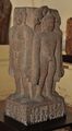
Quadruple Jain Image, excavated from Kankali Tila, c. 1st century CE
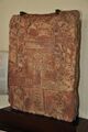
Jain Tablet Homage Set-up by Vasu the daughter of Courtesan Lavana Sobhika - Circa 1st Century CE - Kankali Mound (ACCN 00-Q-7 - Government Museum, Mathura)
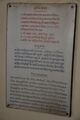
Description of the tablet

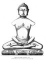
Jina in meditation

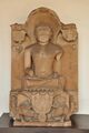
Idol of Rishabhanatha, first Jain Tirthankara, excavated from Kankali Mound (Government Museum - Mathura)
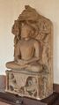
Three Quadruple images of Tirthankar excavated from Kankali Tila, c. 42 BCE(V.S. 15)

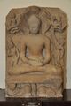
Images of Tirthankar Mahavira excavated from Kankali Tila

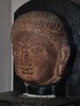
Colossal Head of Jineshvara (Gupta Period)

Jain Images and Stupa - Bronze - Modern Period. Government Museum Mathura
Tirthankar Lord Parshwanatha (1014 CE) Kagarol Government Museum Mathura
Jain Tirthankara Lord Naminatha - (Circa 12th Century CE) ACCN 00-B-77. Government Museum Mathura
Tirthankara Lord Parsvanatha (Post Gupta Period) - Kosi Kalan ACCN 18-1505 Government Museum Mathura

Tirthankara Lord Neminatha (Circa 12th Century CE) ACCN 00-B-77 Government Museum Mathura
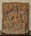
Jain votive plaque (c. 200 CE)

Kankali Tila inscription of Kanishka, Year 5 and 7
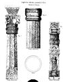
Pillars
Jain Yakshini Ambika (Mediaeval Period) Government Museum Mathura

Jain Yakshini Chakreshvari devi
Jain statue inscribed Samvat 1134 (1077 CE), about 60 years after the sack of Mathura by Mahmud of Ghazni. Kankali Tila, Mathura.[8]


.jpg)


,_Kankali_Tila,_Mathura.jpg)
See also
References
- ↑ The Jain stûpa and other antiquities of Mathurâ by Smith, Vincent Arthur Plate XIV
- ↑ Chandra, Ramaprasad (1919). Memoirs of the archaeological survey of India no.1-5. p. 22. https://archive.org/details/in.gov.ignca.59235.
- ↑ 3.0 3.1 Smith 1901, p. Introduction.
- ↑ Das 1980, p. 171.
- ↑ Smith 1901, p. 2.
- ↑ Thomas 1877, p. 80.
- ↑ The Jaina Stupa at Mathura: Art and Icons, Renuka Porwal, Prachya Vidyapeeth, Shajapur, 2016
- ↑ The Jain Stupa And Other Antiquities Of Mathura. 1901. p. 53. https://archive.org/details/in.ernet.dli.2015.61190.
Sources
- Smith, Vincent Arthur (1901), The Jain stupa and other antiquities of Mathura, Allahabad, Printed by KFrank Luker, Superintendent, Government Press, North-Western Provinces and Oudh, https://archive.org/details/cu31924012251140
- Das, Kalyani (1980), Early Inscriptions of Mathurā, https://books.google.com/books?id=UuwLAAAAIAAJ
- Thomas, Edward (1877), "Jainism or The early faith of Asoka", Nature (London: London, Trübner & co.) 16 (407): 329, doi:10.1038/016329a0, Bibcode: 1877Natur..16..329., https://archive.org/details/jainism_00thom
[ ⚑ ] 27°29′29″N 77°40′26″E / 27.491389°N 77.673889°E
 |

