Social:Pee Pee Island
[ ⚑ ] 47°11′29″N 52°50′14″W / 47.19139°N 52.83722°W
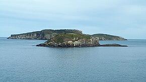
 Pee Pee Island in foreground with Great Island in background, 2020 | |
| Geography | |
|---|---|
| Location | Newfoundland and Labrador |
| Coordinates | [ ⚑ ] 47°11′29″N 52°50′14″W / 47.19139°N 52.83722°W |
| Administration | |
Canada | |
| Additional information | |
| Time zone |
|
Pee Pee Island is a small island located in the province of Newfoundland and Labrador in the far east of Canada .[1] It is the smallest of the four islands in the Witless Bay Ecological Reserve, which it became a part of in 1983. It serves as a breeding place for Atlantic puffins.[2]
Name
Shortly after it was incorporated into the Witless Bay Ecological Reserve in 1983, its name was changed from "Pebble Island" to "Pee Pee Island".[3] Its current name makes it the subject of various online memes and jokes, which some believe to be a deliberate or accidental reference to a penis.[4]
Description
Pee Pee Island provides a breeding ground for up to 1300 pairs of Atlantic Puffin and is part of the largest Atlantic Puffin colony in North America.[3] The island is made up of layers of dark grey sandstone and shale.[3] It is only 250 metres from the mainland and easily viewed from the village of Saint Micheals and the East Coast Trail.
The coldest month is February at 6 °C (43 °F), and the hottest August at 14 °C (57 °F).[5] The average annual rainfall is 1,517 mm, with the wettest month being January with an average of 185 mm and the driest month July with 71 mm of precipitation.[6]
References
- ↑ Government of Canada, Natural Resources Canada. "Place names - Pee Pee Island". http://www4.rncan.gc.ca/search-place-names/unique/ABIDA.
- ↑ "Pee Pee Island Is Real And It's In Newfoundland | Newfoundland Buzz". 18 January 2023. https://newfoundlandbuzz.ca/pee-pee-island/.
- ↑ 3.0 3.1 3.2 Government of Canada, Department of Fisheries and Land Resources. "Witless Bay Ecological Reserve - Management Plan". https://www.gov.nl.ca/ecc/files/natural-areas-pdf-witless-bay-ecological-reserve.pdf.
- ↑ "Google Map Top Fails (very epic fails)". 2019-03-24. https://www.youtube.com/watch?v=DJQvOaj00IE.
- ↑ "Browse datasets | NASA Earth Observations (NEO)" (in en). 2019-03-04. https://neo.sci.gsfc.nasa.gov/dataset_index.php.
- ↑ "Rainfall (1 month - TRMM, 1998-2016)" (in en). NASA. 2019-03-04. https://neo.sci.gsfc.nasa.gov/view.php?datasetId=TRMM_3B43M&year=2014.
 |


