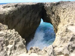
Unsolved:Pozo de Jacinto
Pozo de Jacinto (Jacinto's Pit Cave) is a blowhole located at Barrio Bajuras in the northwestern side Puerto Rican municipality of Isabela on Puerto Rico Highway 466.
Description
Pozo de Jacinto is at Barrio Bajura which is near Crash Boat Beach in Aguadilla, which borders Isabela. It's a blowhole, or limestone rock with an orifice through which ocean waves shoot up.[1][2]
Folklore
A jíbaro named Jacinto often went near the cave to eat his lunch, keeping the cow's leash tied around his waist. One day, loud thunder scared the cow and he ran, fell down the pit pulling Jacinto with him and both drowned. If Jacinto's name is called and mention of the cow is made, the ocean becomes furious and churns wildly in response.[3][4][2]
See also
- Folklore of Puerto Rico
- Barrio Bajuras
- Jobos Beach
References
- ↑ "The 6 best surfing spots in Puerto Rico you should check out". October 15, 2020. https://www.redbull.com/us-en/best-surf-spots-in-puerto-rico.
- ↑ 2.0 2.1 Cruz Ríos, Melissa (January 30, 2021). "Nuevo 'ride' turístico en Isabela" (in es). El Vocero de Puerto Rico. https://www.elvocero.com/actualidad/nuevo-ride-tur-stico-en-isabela/article_1213dca4-6313-11eb-8279-2fd8c440f477.html.
- ↑ "La leyenda del Pozo de Jacinto" (in es). El Vocero. May 26, 2016. https://www.elvocero.com/actualidad/la-leyenda-del-pozo-de-jacinto/article_eeacaae6-d4d8-507d-a8b9-8cf8bf20a5ee.html.
- ↑ "Pozo de Jacinto, Isabela - Ruta Marina | EnciclopediaPR". https://enciclopediapr.org/ruta-marina/puntas/pozo-jacinto-isabela/.
External links
- Global Location at Google Maps
- Driving Location at Mapquest
[ ⚑ ] 18°30′54″N 67°04′26″W / 18.515000°N 67.073877°W
 |


