Unsolved:Winston's Hiccup
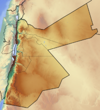
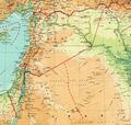
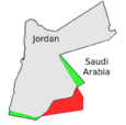
"Winston's Hiccup", also referred to as "Churchill's Sneeze",[1] (Arabic: حازوقة وينستون) is an apocryphal[1] name for the abruptly concave section of Jordan's eastern border with Saudi Arabia, causing the border to resemble a zigzag shape.
Origin of the legend
The legend arose based on an account of Winston Churchill (then serving as the Secretary of State for the Colonies) boasting in his later years that he had created the British protectorate of Transjordan in 1921 "with the stroke of a pen, one Sunday afternoon in Cairo";[2] some stories purport that this drawing of the boundary took place following a "particularly liquid lunch".[1]
According to Warren Dockter, it likely stems from “a misquote from Churchill's speech in the House of Commons on 24 March 1936 when Churchill declared, 'The Emir Abdullah is in TransJordania where I put him one Sunday afternoon at Jerusalem'”[3][4] Churchill was in Jerusalem for the Cairo Conference between Friday 25 March and Wednesday 30 March 1921; he was to have his first meeting with Abdullah on Monday 28 March.[5]
Creation of the border
The borders between Transjordan and the Sultanate of Nejd (the predecessor of Saudi Arabia) were not, in fact, discussed at the 1921 Cairo Conference.
In July 1922, Ibn Saud’s Wahabi forces took Jauf, and in September Abdullah’s forces took Kaf.[6] The hiccup was first sketched out in October 1922 by the Colonial Office during Abdullah’s visit to London.[lower-alpha 1] The first formal definition of the boundary between Transjordan and Nejd was the result of negotiations between the British Government and the Sultan of Nejd starting in 1922, negotiated further at the failed 1923-24 Kuwait Conference,[8] and concluded with the Al Hadda Agreement on November 2, 1925.[9] Sir Gilbert Clayton conducted the talks with the sultan as British representative; Churchill had no involvement in the Al Hadda Agreement during which time he was the British Chancellor of the Exchequer.[10][11]
The “hiccup” resulted from giving the strategic Wadi Sirhan region, and its then primary settlement of Kaf, which had previously been occupied by Abdullah at the urging of the British, to the Sultanate of Nejd.[12] The 1925 treaty did not create the sharp triangular point in the "hiccup" but instead a short north-south segment of 9.3 km along the 37th meridian east.[10] Border adjustments in the 1965 bilateral agreement between Jordan and Saudi Arabia changed this blunt point into a sharp point at the northern end of the previous north-south segment.[13] The 1965 realignment resulted in some exchange of territory, and Jordan's coastline on the Gulf of Aqaba was lengthened by about 18 kilometers.
Other considerations
Kamal Salibi commented about Churchill's pen stroke in The Modern History of Jordan,
Contrary to Winston Churchill's frequently quoted boast, the country was not really created by a stroke of his pen on a Sunday afternoon in 1921. As already indicated, [Emir] Abdullah in that year had already established himself in Amman by his own initiative, when the British agreed to grant him a six-month option to demonstrate his ability to govern the Transjordanian territory as part of their Palestinian mandate.[14]
Complex and seemingly arbitrary Middle Eastern borders such as Winston's Hiccup often took the movements and lands of tribal nomads into consideration in attempting to create practical borders. In the modern era, Jordan's boundaries with Saudi Arabia, Syria, and Iraq do not generally hamper nomads in their movements, although for a few tribes the borders do technically separate them from traditional grazing areas. Conversely, the border between Jordan and Israel is governed more heavily.
See also
- Geography of Saudi Arabia
- Geography of Jordan
- British Mandate of Palestine
- Amman Governorate
- Zarqa Governorate
- Al Jawf Province
- Al Harrah, Saudi Arabia
- Azraq
- Borders of Jordan
Bibliography
- Paris, Timothy J. (2003). Britain, the Hashemites and Arab Rule: The Sherifian Solution. Routledge. ISBN 978-1-135-77191-1. https://books.google.com/books?id=W02RAgAAQBAJ.
References
- ↑ 1.0 1.1 1.2 Frank Jacobs (6 March 2012). "Winston's Hiccup". The New York Times. http://opinionator.blogs.nytimes.com/2012/03/06/winstons-hiccup/?_php=true&_type=blogs&ref=opinion&_r=0#ftn3.
- ↑ Alexander C. Diener; Joshua Hagen (January 2010). Borderlines and Borderlands: Political Oddities at the Edge of the Nation-state. Rowman & Littlefield. p. 189. ISBN 978-0-7425-5636-2. https://books.google.com/books?id=l_P1gp2dpLoC.
- ↑ Warren Dockter (30 March 2015). Churchill and the Islamic World: Orientalism, Empire and Diplomacy in the Middle East. I.B.Tauris. pp. 317 (note 3). ISBN 978-1-78076-818-2. https://books.google.com/books?id=gVHjBwAAQBAJ&pg=PA317.
- ↑ Hansard, Palestine, 24 March 1936, Volume 310, Column 1114: “I think I made most of the settlements over 14 years ago governing the Palestine situation. The Emir Abdullah is in Transjordania, where I put him one Sunday afternoon at Jerusalem. I acted upon the advice of that very great man Colonel Lawrence, who was at my side in making the arrangements, which I believe have stood the test of time and many changes of government throughout the Middle East“
- ↑ Martin Gilbert (16 October 2007). Churchill and the Jews: A Lifelong Friendship. Henry Holt and Company. pp. 54–64. ISBN 978-0-8050-7880-0. https://books.google.com/books?id=8IXvQteVti8C&pg=PA54.
- ↑ Paris 2003, p. 226-227.
- ↑ Paris 2003, p. 227; Paris cites Clayton note, 25 October 1922 and CO to Samuel and Cox, 31 October 1922, CO 733/37, p. 457+459.
- ↑ Troeller, Gary (23 October 2013). The Birth of Saudi Arabia: Britain and the Rise of the House of Sa'ud. Routledge. pp. 201–. ISBN 978-1-135-16198-9. https://books.google.com/books?id=0cy2AQAAQBAJ&pg=PA201.
- ↑ Yitzhak Gil-Har (1992). "Delimitation Boundaries: Trans-Jordan and Saudi Arabia". Middle Eastern Studies 28 (2): 374–384.
- ↑ 10.0 10.1 Agreement with the Sultan of Nejd Regarding Certain Questions Relating to the Nejd- Trans-Jordan Frontier. Signed at Bahra-Camp, November 2, 1925. League of Nations Treaty Series No. 1423, 1927, p435.
- ↑ http://untreaty.un.org/unts/60001_120000/15/26/00029300.pdf
- ↑ Schofield, Clive H.; Schofield, Richard N. (10 September 2012). The Middle East and North Africa: World Boundaries. Routledge. pp. 175–. ISBN 978-1-134-88028-7. https://books.google.com/books?id=9AYhT3zchVMC&pg=PT175.
- ↑ International Boundary Study No. 60 – December 30, 1965 Jordan – Saudi Arabia Boundary
- ↑ Salibi, Kamal (1998). The Modern History of Jordan. I.B.Tauris. pp. 108–109. ISBN 978-1-86064-331-6. https://books.google.com/books?id=7zdi2sCuIh8C&pg=PA104. Retrieved 6 July 2018.
Notes
- ↑ Paris writes: “During his visit to London in October 1922, Abdullah agreed formally to concede Jauf to Ibn Saud, provided Azraq and Kaf remained in Transjordan and the Wahhabis were prevented from moving beyond Jauf or towards the Hijaz railway between Ma‘an and Medina. With Abdullah’s objectives in mind, the Colonial Office proposed a specific border to Samuel that left both Kaf and the air route within Transjordan. The suggested boundary did not differ significantly from the present Saudi-Jordanian border, except that the 1922 proposal placed approximately 60 miles of Wadi Sirhan in Transjordan, and the Wadi is now held almost entirely by Saudi Arabia.”[7]
External links


