Earth:Cow Cave
From HandWiki
Revision as of 08:52, 12 November 2021 by imported>John Stpola (change)
Short description: Cave in Devon, England
| Cow Cave | |
|---|---|
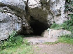
 The entrance to Cow Cave | |
| Lua error in Module:Location_map at line 522: Unable to find the specified location map definition: "Module:Location map/data/Devon" does not exist. | |
| Location | Chudleigh Rock, Devon, England |
| OS grid | SX 86469 78668 |
| Coordinates | [ ⚑ ] 50°35′48″N 3°36′20″W / 50.596675°N 3.605426°W |
| Geology | Limestone |
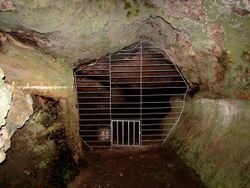
| Access | Gated |
Cow Cave is a limestone cave system which is situated on the south side of the Chudleigh Rocks, close to the town of Chudleigh, Devon, England. It is listed as a Scheduled Monument by Historic England and was first listed in 1992.[1]
Description
The entrance to the cave is situated on the side of a large limestone outcrop known as Chudleigh Rocks. The entrance, which is arched, is approximately 4.5 metres high and 5 metres in width.[1]
Excavations
Cow Cave is known to contain significant deposits of material from the Paleolithic period.
A significant excavation was carried out in 2016.[2]
References
- ↑ 1.0 1.1 Historic England. "Cow Cave, Chudleigh Rocks, Chudleigh (1010726)". National Heritage List for England. https://HistoricEngland.org.uk/listing/the-list/list-entry/1010726. Retrieved 2019-08-09.
- ↑ "Cow Cave, Chudleigh, Devon". https://archaeologydataservice.ac.uk/archives/view/cowcave_he_2017/index.cfm.
Further reading
 |


