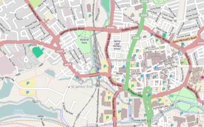
Module:Location map/data/United Kingdom Northampton Central/doc
From HandWiki
< Module:Location map | data/United Kingdom Northampton Central
Revision as of 06:59, 12 May 2018 by imported>Frietjes
This is the documentation page for Module:Location map/data/United Kingdom Northampton Central
| name | Northampton | |||
|---|---|---|---|---|
| border coordinates | ||||
| 52.246223 | ||||
| -0.927401 | ←↕→ | -0.885022 | ||
| 52.230034 | ||||
| map center | [ ⚑ ] 52°14′17″N 0°54′22″W / 52.2381285°N 0.90621149999998°W | |||
| image | Location map United Kingdom Northampton Central.png
| |||

| ||||
Module:Location map/data/United Kingdom Northampton Central is a location map definition used to overlay markers and labels on an equirectangular projection map of Northampton. The markers are placed by latitude and longitude coordinates on the default map or a similar map image.
Usage
These definitions are used by the following templates when invoked with parameter "United Kingdom Northampton Central":
{{Location map|United Kingdom Northampton Central |...}}{{Location map many|United Kingdom Northampton Central |...}}{{Location map+|United Kingdom Northampton Central |...}}{{Location map~|United Kingdom Northampton Central |...}}
Map definition
name = Northampton- Name used in the default map caption
image = Location map United Kingdom Northampton Central.png- The default map image, without "Image:" or "File:"
top = 52.246223- Latitude at top edge of map, in decimal degrees
bottom = 52.230034- Latitude at bottom edge of map, in decimal degrees
left = -0.927401- Longitude at left edge of map, in decimal degrees
right = -0.885022- Longitude at right edge of map, in decimal degrees
Precision
Longitude: from West to East this map definition covers 0.0424 degrees.
- At an image width of 200 pixels, that is 0.0002 degrees per pixel.
- At an image width of 1000 pixels, that is 0 degrees per pixel.
Latitude: from North to South this map definition covers 0.0162 degrees.
- At an image height of 200 pixels, that is 0.0001 degrees per pixel.
- At an image height of 1000 pixels, that is 0 degrees per pixel.
See also
Location map templates
- Template:Location map, to display one mark and label using latitude and longitude
- Template:Location map many, to display up to nine marks and labels
- Template:Location map+, to display an unlimited number of marks and labels
