Earth:Pemberton Volcanic Belt
From HandWiki
Short description: Volcanic belt in British Columbia, Canada
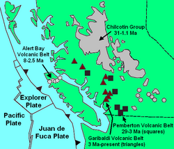
The Pemberton Volcanic Belt is an eroded Oligocene-Miocene volcanic belt at a low angle near the Mount Meager massif, British Columbia, Canada . The Garibaldi and Pemberton volcanic belts appear to merge into a single belt, although the Pemberton is older than the Garibaldi Volcanic Belt. The Pemberton Volcanic Belt is one of the geological formations comprising the Canadian Cascade Arc. It formed as a result of subduction of the former Farallon Plate.
Features
Features within the Pemberton Belt include:
- Mount Barr Plutonic Complex
- Mount Barr
- Chilliwack batholith
- Chipmunk Mountain [ ⚑ ] 50°34′49.87″N 122°55′56.47″W / 50.5805194°N 122.9323528°W
- Coquihalla Mountain [ ⚑ ] 49°31′30.0″N 121°03′36.0″W / 49.525°N 121.06°W
- Crevasse Crag
- Franklin Glacier Complex
- Salal Creek Pluton
- Silverthrone Caldera
See also
- Garibaldi Volcanic Belt
- Geology of the Pacific Northwest
- Cascade Volcanoes
- Volcanism of Canada
- Volcanism of Western Canada
References
 |


