Earth:Harrat al-Sham
| Ḥarrat al-Shām | |
|---|---|
| Black Desert | |
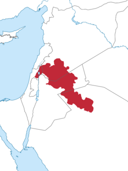
 Location within the Levant of the wider volcanic province it is part of | |
| Coordinates | Lua error in package.lua at line 80: module 'strict' not found. |
| Part of | Syrian Desert |
| Offshore water bodies |
|
| Geology | Basaltic volcanic field |
| Age | Oligocene, Neogene, Quaternary |
| Volcanic field | Harrat Ash Shaam Volcanic Province (HASV) |
The Ḥarrat al-Shām (Arabic: حَرَّة ٱلشَّام),[1][nb 1] also known as the Black Desert,[2] is a region of rocky, basaltic desert straddling southern Syria and the northern Arabian Peninsula. It covers an area of some 40,000 km2 (15,000 sq mi)[citation needed] in the modern-day Syrian Arab Republic, Jordan, Israel and Saudi Arabia. Vegetation is characteristically open acacia shrubland with patches of juniper at higher altitudes.[3]
The Harrat has been occupied by humans since at least the Late Epipalaeolithic period (c. 12,500–9500 BCE).[4] One of the earliest known sites is Shubayqa 1 (occupied c. 12,600–10,000 BCE),[4][5] where archaeologists have discovered the remains of the oldest known bread.[6]
Geology

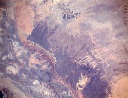
The Harrat comprises volcanic fields formed by tectonic activity from the Oligocene through to the Quaternary period.[7] It is the largest of several volcanic fields on the Arabian Plate,[8] containing more than 800 volcanic cones and around 140 dikes.[7] Activity began during the Miocene; a younger eruptive stage, at the SE end of the volcanic field, occurred during the late-Pleistocene and Holocene.[9] It is known to have erupted in historic times.[10][11]
The Jabal al-Druze, al-Safa and Dirat al-Tulul volcanic fields, among others, form the northern and Syrian part of the harrat. The Saudi Arabian portion of the Harrat Ash Shamah volcanic field extends across a 210 km (130 mi)-long, roughly 75 km (47 mi)-wide NW-SE-trending area on the NE flanks of the Sirhan Valley and reaches its 1,100 metres (3,600 ft) high point at Jabal Al-Amud. It is in the Tabuk Region of northwest Saudi Arabia.[12][13] and is one of a series of Quaternary volcanic fields paralleling the Red Sea coast.
Archaeological sites
Jordan
- Jawa, Early Bronze Age proto-urban settlement
- Qasr Azraq and Qasr 'Ain es-Sil, ancient fortified sites in the Azraq Oasis
- Qasr Burqu', ancient "desert castle"
- Qasr Usaykhim, ancient fort northeast of Azraq
- Shubayqa 1, Stone Age (Natufian) hunter-gatherer site with oldest bread-making find in the world
See also
- Badia region
- Hauran, historical region partially overlapping with Harrat al-Sham
- List of volcanoes in Saudi Arabia
- Sarat Mountains
- Midian Mountains
Notes
- ↑ Variously transcribed as the harra, Ḥarrat ash-Shāmah (حَرَّة ٱلشَّامَة) or Ḥarrate-Shāmah (حَرَّةِ شَامَة).[citation needed]
References
- ↑ Ibrahim, K. (1993), The geological framework for the Harrat Ash-Shaam Basaltic Super-Group and its volcanotectonic evolution, Jordan: Bulletin 24, Geological Mapping Division, Natural Resources Authority
- ↑ Betts, Alison (1982). "A Natufian site in the Black Desert, Eastern Jordan". Paléorient 8 (2): 79–82. doi:10.3406/paleo.1982.4322. ISSN 0153-9345.
- ↑ S.A. Ghazanfar, Vegetation of the Arabian Peninsula (Springer Science & Business Media, 1998) p 272.
- ↑ 4.0 4.1 Richter, Tobias (2017). "Natufian and early Neolithic in the Black Desert". in Enzel, Yehouda; Bar-Yosef, Ofer. Quaternary of the Levant: Environments, Climate Change, and Humans. Cambridge: Cambridge University Press. pp. 715–722. ISBN 978-1-107-09046-0.
- ↑ Richter, Tobias; Arranz-Otaegui, Amaia; Yeomans, Lisa; Boaretto, Elisabetta (5 December 2017). "High Resolution AMS Dates from Shubayqa 1, northeast Jordan Reveal Complex Origins of Late Epipalaeolithic Natufian in the Levant" (in en). Scientific Reports 7 (1): 17025. doi:10.1038/s41598-017-17096-5. ISSN 2045-2322. PMID 29208998. Bibcode: 2017NatSR...717025R.
- ↑ Arranz-Otaegui, Amaia; Carretero, Lara Gonzalez; Ramsey, Monica N.; Fuller, Dorian Q.; Richter, Tobias (31 July 2018). "Archaeobotanical evidence reveals the origins of bread 14,400 years ago in northeastern Jordan" (in en). Proceedings of the National Academy of Sciences 115 (31): 7925–7930. doi:10.1073/pnas.1801071115. ISSN 0027-8424. PMID 30012614.
- ↑ 7.0 7.1 Al Kwatli, Mohamad Amer; Gillot, Pierre Yves; Lefèvre, Jean Claude; Hildenbrand, Anthony (2015-09-01). "Morpho-structural analysis of Harrat Al Sham volcanic field Arabian plate (Syria, Jordan, and Saudi Arabia): methodology and application" (in en). Arabian Journal of Geosciences 8 (9): 6867–6880. doi:10.1007/s12517-014-1731-1. ISSN 1866-7538.
- ↑ Krienitz, M.-S.; Haase, K. M.; Mezger, K.; Shaikh-Mashail, M. A. (2007-08-01). "Magma Genesis and Mantle Dynamics at the Harrat Ash Shamah Volcanic Field (Southern Syria)" (in en). Journal of Petrology 48 (8): 1513–1542. doi:10.1093/petrology/egm028. ISSN 0022-3530. https://academic.oup.com/petrology/article/48/8/1513/1471610.
- ↑ H. Stewart Edgell, Arabian Deserts: Nature, Origin and Evolution (Springer Science & Business Media, 21Jul.,2006 ) p329-330
- ↑ Geological Survey Professional Paper. U.S. Government Printing Office. 1989. p. 153. https://books.google.com/books?id=jhwlAQAAIAAJ&pg=SL1-PA153.
- ↑ Peter Vincent, Saudi Arabia: An Environmental Overview (CRC Press, 2008) p22.
- ↑ U.S. Geological Survey Professional Paper (U.S. Government Printing Office, 1989) pA152
- ↑ Geological Survey Professional Paper, Volume 560, Part 1 (U.S. Government Printing Office, 1989)
Further reading
- Ilani, S., Harlavan, Y., Tarawneh, K., Rabba, I., Weinberger, R., Khalil, I., and Peltz, S. (2001), "New K-Ar ages of basalts from the Harrat Ash Shaam volcanic field in Jordan: Implications for the span and duration of the upper-mantle upwelling beneath the western Arabian plate" Geology 29(2):171–174
- Kempe, S. and Al-Malabeh, A. (2005), "Newly discovered lava tunnels of the Al-Shaam plateau basalts", Geophysical Research Abstracts 7, European Geosciences Union
- Salf, S.I. (1988), "Field and petrographic characteristics of Cenozoic basaltic rocks, Northwestern Saudi Arabia" Journal of African Earth Sciences, 7(5):805–809
- Weinstein, Y., Navon, O., Altherr, R., and Stein, M., (2006) "The role of lithospheric mantle heterogeneity in the generation of Plio-Pleistocene alkali basalt suites from NW Harrat Ash Shaam (Israel)", Journal of Petrology 47(5):1017–1050
- Al Kwatli, M.A., Gillot, P.Y., Zeyen, H., Hildenbrand, A., and Al Gharib, I., 2012. Volcano-tectonic evolution of the northern part of the Arabian plate in the light of new K-Ar ages and remote sensing: Harrat Ash Shaam volcanic province (Syria). Tectonophysics, 580, 192–207.
External links
- "Harrat Ash Shaam". Smithsonian Institution. https://volcano.si.edu/volcano.cfm?vn=231001.
- VolcanoWorld information and aerial photograph
 |


