Earth:Taltson Magmatic Zone
| Taltson Magmatic Zone | |
|---|---|
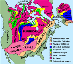
 Map of cratons and basement rock of North America. The Taltson Magmatic Zone is the north-south trending green line extending from the Wyoming craton in the south to the southeastern end of the Rae craton in the north. | |
| Location | Alberta, Canada |
| Geology | Magmatic arc |
The Taltson Magmatic Zone (TMZ) is a north-trending belt of Archean to Paleoproterozoic granitic basement gneiss, amphibolite supracrustal gneissic rock and Paleoproterozoic magmatic rocks in the Canadian Shield, extending from Northern Alberta to the southwestern Northwest Territories.[1] The TMZ basement is 3.2–3.0 Ga and the Rutledge River supracrustal gneisses 2.13–2.09 Ga years old and were intruded by magmatic rocks around 1.99–1.92 Ga.[2]
The 300 km (190 mi) long exposed part of the TMZ in Northern Alberta and the Northwest Territories is bounded by the Great Slave Lake shear zone to the north and by the subsurface Snowbird Tectonic Zone to the south. TMZ is an Andean-type continental magmatic arc and an orogenic belt between the subsurface Buffalo Head Terrane on the west and the Archean Churchill Province on the east. It is also the southern continuation of the Thelon Magmatic Zone, an orogenic belt between the Slave and Churchill cratons.[3] The northern TMZ is divided by major faults and can be subdivided into two main terranes: an eastern gneiss framework and the TMZ batholiths in the west.[4]
The exposed basement in northern Alberta is composed of banded gneissic rocks, predominantly 2.4–2.1 Ga metaplutonic gneissic rock, but it also contains amphibolitic gneiss and paragneiss. This basement also contains slices of Archean gneissic rock up to 3.73 Ga-old; an age similar to those of the Hearne and Rae cratons (also known as the Western Churchill Province), which can indicate that TMZ represents the recycling of parts of this province.[1]
The U–Pb ages and the isotopic composition of TMZ and the Buffalo Head Terrane (west of TMZ), including the Buffalo Head Hills kimberlite field, are identical. It is possible that these two domains represent a single Paleoproterozoic block. This block is composed mostly of contribution from depleted mantle sources but with contribution from the Churchill Province. TMZ basement rock together with the Buffalo Head terrane can represent the earliest Paleoproterzoic magmatism, pre-dating the break-up of the Churchill Province and the Taltson–Thelon orogeny.[1]
See also
- Great Bear Magmatic Zone
- Volcanism of Canada
- Volcanism of Northern Canada
- Volcanism of Western Canada
References
- Notes
- ↑ 1.0 1.1 1.2 McNicoll, Thériault & McDonough 2000, Abstract
- ↑ McDonough et al. 2000, Abstract
- ↑ McDonough & McNicoll 1997, Geological setting, p. 102
- ↑ Bostock, van Breemen & Loveridge 1991, Introduction, p. 68
- Sources
- Bostock, H. H.; van Breemen, O.; Loveridge, W. D. (1991). "Further geochronology of plutonic rocks in northern Taltson magmatic zone, District of Mackenzie, NWT". Radiogenic Age and Isotopic Studies. Report 4: 67–78. http://www.iaea.org/inis/collection/NCLCollectionStore/_Public/24/005/24005624.pdf. Retrieved 29 May 2016.
- McDonough, M. R.; McNicoll, V. J. (1997). "U–Pb age constraints on the timing of deposition of the Waugh Lake and Burntwood (Athabasca) groups, southern Taltson magmatic zone, northeastern Alberta" (PDF). Radiogenic Age and Isotopic Studies: Report 10: 101–111. http://emrlibrary.gov.yk.ca/gsc/current_research/1997-F.pdf#page=109. Retrieved 29 May 2016.
- McDonough, M. R.; McNicoll, V. J.; Schetselaar, E. M.; Grover, T. W. (2000). "Geochronological and kinematic constraints on crustal shortening and escape in a two-sided oblique-slip collisional and magmatic orogen, Paleoproterozoic Taltson magmatic zone, northeastern Alberta". Canadian Journal of Earth Sciences 37 (11): 1549–1573. doi:10.1139/e00-089.
- McNicoll, V. J.; Thériault, R. J.; McDonough, M. R. (2000). "Taltson basement gneissic rocks: U Pb and Nd isotopic constraints on the basement to the Paleoproterozoic Taltson magmatic zone, northeastern Alberta". Canadian Journal of Earth Sciences 37 (11): 1575–1596. doi:10.1139/e00-034.
 |

