Biology:Acacia eremophiloides
| Acacia eremophiloides | |
|---|---|
| Scientific classification | |
| Kingdom: | Plantae |
| Clade: | Tracheophytes |
| Clade: | Angiosperms |
| Clade: | Eudicots |
| Clade: | Rosids |
| Order: | Fabales |
| Family: | Fabaceae |
| Subfamily: | Caesalpinioideae |
| Clade: | Mimosoid clade |
| Genus: | Acacia |
| Species: | A. eremophiloides
|
| Binomial name | |
| Acacia eremophiloides Pedley & P.I.Forst.
| |

| |
| Occurrence data from AVH | |
Acacia eremophiloides is a shrub belonging to the genus Acacia and the subgenus Phyllodineae that is endemic to Queensland.
Description
The resinous, glabrous shrub typically grows to a height of 2.5 m (8 ft 2 in) and has slender branchlets.[1] The evergreen phyllodes are patent to erect and have a linear shape that can be shallowly incurved. The phyllodes have a length of 3 to 6.5 cm (1.2 to 2.6 in) and a width of 2.5 to 4 mm (0.098 to 0.157 in) and narrow toward the base and have a prominent midrib and margins.
The shrub produces simple inflorescences occurring singly or in pairs in the axils. The spherical flower-heads contain 20 to 30 golden coloured flowers. The linear cinnamon brown seed pods that form after flowering are convex over the seeds and are up to 8 cm (3.1 in) in length and 3.5 to 5 mm (0.14 to 0.20 in) wide. The pods contain longitudinally arranged seeds with a length of 3.3 mm (0.13 in).[2]
Taxonomy
The species was first formally described by the botanists Leslie Pedley and P.I.Forst on 1986 as part of the work Acacia eremophiloides (Mimosaceae) A new species from south-eastern Queensland published in the journal Austrobaileya. It was reclassified by Pedley in 1987 as Racosperma eremophiloides then transferred back to genus Acacia in 2001.[3]
Distribution
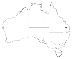
It is confined to a small area of South East Queensland in the Bunrett pastoral district. The population is around 45 km (28 mi) south west of Gayndah and a similar distance south east from Mundubbera. The population has a range of around 10 km (6.2 mi) and is composed of around 5,000 plants.[1] It is situated within an area of 4 to 5 ha (9.9 to 12.4 acres) and is found on an among granite outcrop at an altitude of 460 to 550 mm (18 to 22 in).[2]
See also
References
- ↑ 1.0 1.1 "Acacia eremophiloides". Species Profile and Threats Database. Department of the Environment and Energy. http://www.environment.gov.au/cgi-bin/sprat/public/publicspecies.pl?taxon_id=9280.
- ↑ 2.0 2.1 "Acacia eremophiloides Pedley & P.I.Forst.". Wattle - Acacias of Australia. CSIRO publishing. https://apps.lucidcentral.org/wattle/text/entities/acacia_eremophiloides.htm.
- ↑ "Acacia eremophiloides Pedley & P.I.Forst.". Atlas of Living Australia. Global Biodiversity Information Facility. https://bie.ala.org.au/species/http://id.biodiversity.org.au/node/apni/2911272#names.
Wikidata ☰ Q9564480 entry
 |


