Earth:Cardenas Butte
| Cardenas Butte | |
|---|---|
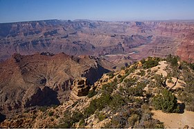
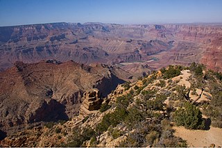
 Cardenas Butte-(left, (Esplanade Sandstone)), lower butte (Manakacha Formation-(shelf-center-left)) | |
| Highest point | |
| Elevation | 6,281 ft (1,914 m) [1] |
| Prominence | 481 ft (147 m) [1] |
| Parent peak | Escalante Butte |
| Isolation | 0.80 mi (1.29 km) [2] |
| Coordinates | [ ⚑ ] : 36°03′34″N 111°50′34″W / 36.0593551°N 111.8427094°W [3] |
| Geography | |
Lua error in Module:Location_map at line 522: Unable to find the specified location map definition: "Module:Location map/data/Arizona" does not exist.
| |
| Location | Grand Canyon National Park Coconino County, Arizona, US |
| Parent range | Coconino Plateau Colorado Plateau |
| Topo map | USGS Desert View |
| Geology | |
| Age of rock | Pennsylvanian down to Cambrian |
| Mountain type | sedimentary rock: sandstone, siltstone, mudstone, sandstone, shale |
| Type of rock | Supai Group-(eroded ridgeline), Redwall Limestone, Muav Limestone, Bright Angel Shale |
Cardenas Butte is a 6,281-foot-elevation summit located in the eastern Grand Canyon, in Coconino County of northern Arizona, Southwestern United States. Cardenas Butte is named for García López de Cárdenas, the first European to see the Grand Canyon. The butte is located on a dp orange-red ridgeline of the Supai Group, adjacent its higher elevation neighbor, Escalante Butte; both buttes are ~1.5 miles north-northwest of Navajo Point in far eastern South Rim, approaching the East Rim.
Cardenas Butte (and Escalante) are drained on the east by Tanner Canyon, north to the Colorado River; the northwest of Cardenas Butte is drained northwest by Cardenas Creek, and north by an unnamed drainage. The Tanner Trail from Navajo Point, courses the east, upper ridges of Escalante, then Cardenas Butte, upon the Supai Group, until the trail drops down through the Redwall Limestone, at the Supai ridgeline terminus. Cardenas Butte and Escalante Butte have similar elevations, with Escalante about 300 ft higher, and westwards up the burnt-orange-red ridgeline.
Geology of Cardenas and Escalante Buttes
Cardenas Butte and Escalante Butte lie upon the same Supai Group ridgeline. At the west, Escalante is separated by a ridge saddle (the drainage southeast into Upper Tanner Canyon). Escalante Butte prominence is a small, heavily eroded cliff and debris remainder of Coconino Sandstone, (on Hermit Shale), on eroded ridges of the Supai Group.
Cardenas Butte, is about 300 ft lower than Escalante Butte, and 0.8 mi east, on an eroded ridgeline of Supai Group. Its small spire is a surviving cliff-former unit of the Supai Group, the cliff and shelf of the Esplanade Sandstone. A small amount of debris-remainder may survive on the surface of the prominence-shelf, the slope-former Hermit Shale.[4]
See also
- Geology of the Grand Canyon area
- Escalante Butte
- Tanner Trail
- List of Supai Group prominences in the Grand Canyon
References
External links
- Closeup View of Cardenas Peak, Summitpost (type name)
- View of Escalante Butte, and Supai Group ridgeline, with Cardenas Butte; Summitpost. (Choose Escalante Butte)
 |


