Earth:Tenjong Dendang Formation
From HandWiki
Short description: Malaysian geologic formation
| Tenjong Dendang Formation Stratigraphic range: Hirnantian ~446–444 Ma | |
|---|---|
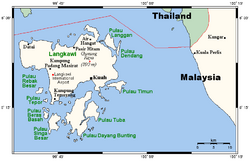
 Map of Langkawi, the formation is found on the island in the northeast; Langgan | |
| Type | Formation |
| Lithology | |
| Primary | Limestone |
| Other | Shale |
| Location | |
| Coordinates | [ ⚑ ] : 6°24′N 99°54′E / 6.4°N 99.9°E |
| Paleocoordinates | [ ⚑ ] 23°42′N 133°00′E / 23.7°N 133.0°E |
| Region | Langgan, Kuah, Langkawi |
| Country | |
| Type section | |
| Named for | Tanjong Dendang point |
| Lua error in Module:Location_map/multi at line 27: Unable to find the specified location map definition: "Module:Location map/data/Malaysia Kedah" does not exist. | |
The Tenjong Dendang Formation is a geologic formation in Malaysia. The band of graptolite- and trilobite-bearing shales interbedded in limestones preserves graptolite, brachiopod and trilobite fossils dating back to the Hirnantian stage of the Late Ordovician period.[1] The sediments were deposited during the Late Ordovician glaciation.
Fossil content
The following fossils were reported from the formation:[1][2]
Trilobites
- Mucronaspis mucronata
- ?Stenopareia sp.
Hyolitha
Strophomenata
Gastropods
- Lophospira sp.
- ?Megalomphala sp.
Pterobranchia
See also
- Soom Shale, Hirnantian fossiliferous formation of South Africa
- Tufs et calcaires de Rosan, Hirnantian fossiliferous formation of France
- Cancañiri Formation, Hirnantian fossiliferous formation of Bolivia
References
- ↑ Jump up to: 1.0 1.1 Tenjong Dendang Formation at Fossilworks.org
- ↑ Kobayashi et al., 1964
Bibliography
- Kobayashi, T.; C. R. Jones, and T. Hamada. 1964. On the Lower Silurian shelly fauna in the Langkawi Islands, Northwest Malaya. Japanese Journal of Geology and Geography 35. 73–80.
 |

