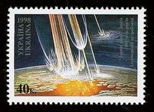
Earth:Ilyinets crater
From HandWiki
 Ukrainian stamp: "Star wounds" of the Earth. 400 million years Ilyinets astrobleme | |
| Impact crater/structure | |
|---|---|
| Confidence | Confirmed |
| Diameter | 8.5 kilometres (5.3 mi) |
| Age | 378 ± 5 Ma |
| Exposed | No |
| Drilled | Yes |
| Bolide type | Iron? |
| Location | |
| Country | Ukraine |
| Lua error in Module:Location_map at line 422: No value was provided for longitude. | |
Ilyinets is an impact crater in Ukraine (Vinnytsia Oblast).[1][2][3]
It is 8.5 kilometres (5.3 mi) in diameter and the age is estimated to be 378 ± 5 million years (Upper Devonian). The crater is not exposed at the surface.
The Ilyinets crater is located at the boundary of Rosynsko-Tikychki, Dnistersko-Buzki megastructures of the Ukrainian Shield.[4]
References
- ↑ "Ilyinets". Earth Impact Database. Planetary and Space Science Centre University of New Brunswick Fredericton. http://www.passc.net/EarthImpactDatabase/New%20website_05-2018/Ilyinets.html. Retrieved 2009-08-15.
- ↑ "Meteoritical Bulletin: Entry for Ilyinets". https://www.lpi.usra.edu/meteor/metbull.php?code=35227.
- ↑ 1984LPI....15..335G Page 335. Bibcode: 1984LPI....15..335G. http://adsabs.harvard.edu/full/1984LPI....15..335G.
- ↑ Іллінецький метеоритний кратер – виняткова геологічна споруда Європи та перспективний об’єкт міжнародного туризму (p. 660)
External links
[ ⚑ ] 49°7′N 29°6′E / 49.117°N 29.1°E
 |


