Astronomy:Phocylides (crater)
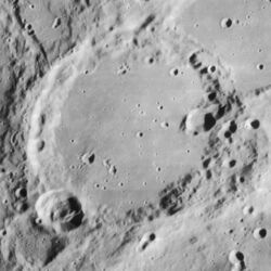
 Lunar Orbiter 4 image | |
| Diameter | 114 km |
|---|---|
| Depth | 2.1 km |
| Colongitude | 56° at sunrise |
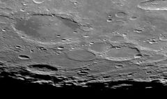
Phocylides is a lunar impact crater located near the southwest rim of the Moon. It overlays the south rim of the crater Nasmyth to the north. To the northwest is the unusual plateau formation of Wargentin. Eastward is the merged formation Schiller, and in the southwest lies Pingré.
The outer wall of Phocylides is worn and eroded, especially along the western edge. The northern edge of the rim is notched and irregular, with a rise of ground joining the south rim of Wargentin. The crater Phocylides F lies across the southern rim. The floor of Phocylides is flooded and relatively smooth, with a few small craterlets and no central peak. The most notable impact on the floor is a crater near the northeast rim.
Phocylides lies to the northwest of the Schiller-Zucchius Basin.
Satellite craters
By convention these features are identified on lunar maps by placing the letter on the side of the crater midpoint that is closest to Phocylides.
| Phocylides | Latitude | Longitude | Diameter |
|---|---|---|---|
| A | 54.6° S | 51.6° W | 19 km |
| B | 53.8° S | 51.7° W | 8 km |
| C | 51.0° S | 52.6° W | 46 km |
| D | 53.2° S | 51.6° W | 7 km |
| E | 55.5° S | 57.7° W | 32 km |
| F | 54.8° S | 57.4° W | 23 km |
| G | 51.2° S | 50.8° W | 14 km |
| J | 54.1° S | 62.7° W | 22 km |
| K | 52.2° S | 48.9° W | 14 km |
| KA | 52.0° S | 48.9° W | 12 km |
| KB | 51.7° S | 48.8° W | 14 km |
| L | 56.9° S | 62.7° W | 9 km |
| M | 55.5° S | 60.5° W | 9 km |
| N | 52.1° S | 55.5° W | 15 km |
| S | 55.9° S | 59.8° W | 10 km |
| V | 56.6° S | 60.6° W | 8 km |
| X | 50.5° S | 50.6° W | 7 km |
| Z | 50.0° S | 50.8° W | 8 km |
References
- Andersson, L. E.; Whitaker, E. A. (1982). NASA Catalogue of Lunar Nomenclature. NASA RP-1097.
- Blue, Jennifer (July 25, 2007). "Gazetteer of Planetary Nomenclature". USGS. http://planetarynames.wr.usgs.gov/.
- Bussey, B.; Spudis, P. (2004). The Clementine Atlas of the Moon. New York: Cambridge University Press. ISBN 978-0-521-81528-4.
- Cocks, Elijah E.; Cocks, Josiah C. (1995). Who's Who on the Moon: A Biographical Dictionary of Lunar Nomenclature. Tudor Publishers. ISBN 978-0-936389-27-1. https://archive.org/details/isbn_9780936389271.
- McDowell, Jonathan (July 15, 2007). "Lunar Nomenclature". Jonathan's Space Report. http://host.planet4589.org/astro/lunar/.
- Menzel, D. H.; Minnaert, M.; Levin, B.; Dollfus, A.; Bell, B. (1971). "Report on Lunar Nomenclature by the Working Group of Commission 17 of the IAU". Space Science Reviews 12 (2): 136–186. doi:10.1007/BF00171763. Bibcode: 1971SSRv...12..136M.
- Moore, Patrick (2001). On the Moon. Sterling Publishing Co.. ISBN 978-0-304-35469-6. https://archive.org/details/patrickmooreonmo00patr.
- Price, Fred W. (1988). The Moon Observer's Handbook. Cambridge University Press. ISBN 978-0-521-33500-3.
- Rükl, Antonín (1990). Atlas of the Moon. Kalmbach Books. ISBN 978-0-913135-17-4.
- Webb, Rev. T. W. (1962). Celestial Objects for Common Telescopes (6th revised ed.). Dover. ISBN 978-0-486-20917-3. https://archive.org/details/celestialobjects00webb.
- Whitaker, Ewen A. (1999). Mapping and Naming the Moon. Cambridge University Press. ISBN 978-0-521-62248-6.
- Wlasuk, Peter T. (2000). Observing the Moon. Springer. ISBN 978-1-85233-193-1.
 |


