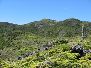
Earth:Mount Yoko (Northern Yatsugatake)
From HandWiki
Short description: Lava dome in Honshū, Japan
| Mount Yoko | |
|---|---|
| 横岳 | |
 | |
| Highest point | |
| Elevation | 2,480 m (8,140 ft) |
| Prominence | 400 m (1,300 ft) |
| Listing | List of mountains and hills of Japan by height |
| Coordinates | [ ⚑ ] : 36°5′15″N 138°19′12″E / 36.0875°N 138.32°E |
| Geography | |
| Location | Honshū, Japan |
| Parent range | Northern Yatsugatake Volcanic Group |
| Topo map | Geographical Survey Institute 25000:1 蓼科山, 25000:1 蓼科, 50000:1 蓼科山 |
| Geology | |
| Age of rock | Quaternary |
| Mountain type | Volcanic |
| Volcanic arc/belt | Northeastern Japan Arc |
| Last eruption | 1200 ±100 years |
Mount Yoko (横岳 Yoko-dake) also Mount Kita Yoko, is an active lava dome located in the Northern Yatsugatake Volcanic Group of the Yatsugatake Mountains, Honshū, Japan . Mount Yoko has shown the most recent activity and is now considered an active volcano. It last erupted about 800 years ago.[1] The eruption consisted of ash with a lava flow of some 3 million cubic meters. The eruption was dated by corrected radiocarbon dating. The next previous eruption was in or after 400 BCE.[2]
References
- ↑ "KITA YATSU-GA-TAKE (TATESHINA-YAMA, YOKO-DAKE etc.)". Quaternary Volcanoes of Japan. Geological Survey of Japan, AIST. 2006. http://riodb02.ibase.aist.go.jp/strata/VOL_JP/EN/vol/65.htm. Retrieved 2008-08-23.
- ↑ "Yokodake". Smithsonian Institution. https://volcano.si.edu/volcano.cfm?vn=283031.
 |

