Earth:Mount Edziza
| Mount Edziza | |
|---|---|
 | |
| Highest point | |
| Elevation | 2,780 m (9,120 ft) [1] |
| Prominence | 1,750 m (5,740 ft) [1] |
| Listing |
|
| Coordinates | [ ⚑ ] : 57°42′56″N 130°38′05″W / 57.71556°N 130.63472°W [2] |
| Geography | |
| District | Cassiar Land District |
| Parent range | Tahltan Highland |
| Topo map | NTS Script error: No such module "Canada NTS".[2] |
| Geology | |
| Age of rock | Pleistocene-to-Holocene |
| Mountain type | Stratovolcano |
| Volcanic arc/belt | Northern Cordilleran Volcanic Province |
| Last eruption | 950 CE ± 1000 years |
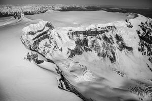
Mount Edziza (/ədˈzaɪzə/) is a stratovolcano in the Stikine Country of northwestern British Columbia, Canada . The volcano and the surrounding area are protected within Mount Edziza Provincial Park. It consists of multiple peaks and ridges, with several glaciers flowing in all directions. The summit is topped by an ice-filled caldera, which is almost 2 km (1 mi) wide. The three main peaks around the summit caldera are the southwest summit, the southeast summit and the north summit. Ice Peak overlaps the southern flank of Mount Edziza.
Mount Edziza is one of Canada's highest volcanoes at 2,780 m (9,121 ft). Snow and ice covered Mount Silverthrone in southwestern British Columbia has a height of 2,864 m (9,396 ft).
History
As early as 10,000 years ago, the Tahltan people, who now live in Dease Lake, Telegraph Creek and the Iskut, used obsidian from Mount Edziza to make tools and weapons for trading material. This is the main source of obsidian found in northwestern British Columbia, which was traded as far away as Alaska and northern Alberta.[3] Obsidian is a type of naturally occurring glass that is highly valued for its cutting qualities. Like all glass and some other types of naturally occurring rocks, obsidian breaks with a characteristic conchoidal fracture, creating razor sharp edges.
More recently, Mount Edziza was made into the Mount Edziza Provincial Park to preserve the volcanic and culture treasures unique to the northern British Columbia area. It encompasses over 230,000 hectares of the Tahltan Highland. There is no vehicle access to the park, and there are only a very few basic facilities.
See also
- List of Northern Cordilleran volcanoes
- Mount Edziza volcanic complex
- Mountain peaks of Canada
- Northern Cordilleran Volcanic Province
- Volcanism of Western Canada
- Geology of the Pacific Northwest
References
- ↑ 1.0 1.1 "British Columbia and Alberta: The Ultra-Prominence Page". Peaklist.org. Retrieved 2012-12-23.
- ↑ 2.0 2.1 "Mount Edziza". Geographical Names Data Base. Natural Resources Canada. http://www4.rncan.gc.ca/search-place-names/unique.php?id=JAEDS&output=xml.
- ↑ Journey & Transformations: British Columbia Landscapes Retrieved on 2007-10-11
External links
- "Mount Edziza". BC Geographical Names. https://apps.gov.bc.ca/pub/bcgnws/names/2256.html.
- ParkWardens
- Skiing the Pacific Ring of Fire and Beyond: Mount Edziza
 |


