Astronomy:Cerberus Palus
From HandWiki
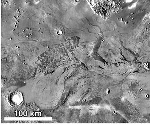
 Cerberus Palus, as seen by THEMIS. | |
| Coordinates | [ ⚑ ] : 5°30′N 150°30′E / 5.5°N 150.5°E |
|---|---|
Cerberus Palus is a plain in the Elysium quadrangle of Mars, centered at [ ⚑ ] 5°48′N 148°06′E / 5.8°N 148.1°E. It is 470 km across and was named after a classical albedo feature Cerberus.[1]
Cerberus Palus once contained a lake fed by Athabasca Valles and draining into Lethe Vallis. According to different researches, it could be a lake of water[2] or lava.[3] It is notable by giant plates (up to 50 km and more), similar to pack ice,[2] but possibly pieces of lava crust.[3] Gaps between the plates contain spiral-shaped geological features, probably lava coils.[3][4]
References
- ↑ "Cerberus Palus". Gazetteer of Planetary Nomenclature. USGS Astrogeology Research Program.
- ↑ 2.0 2.1 Murray J. B.Expression error: Unrecognized word "et". (2005). "Evidence from the Mars Express High Resolution Stereo Camera for a frozen sea close to Mars' equator". Nature 434 (7031): 352–356. doi:10.1038/nature03379. PMID 15772653. Bibcode: 2005Natur.434..352M.
- ↑ 3.0 3.1 3.2 Ryan, A. J.; Christensen, P. R. (26 April 2012). "Coils and Polygonal Crust in the Athabasca Valles Region, Mars, as Evidence for a Volcanic History". Science 336 (6080): 449–452. doi:10.1126/science.1219437. PMID 22539716. Bibcode: 2012Sci...336..449R.
- ↑ Lakdawalla, Emily. "Swirly lava patterns in beautiful HiRISE images". http://www.planetary.org/blogs/emily-lakdawalla/2012/20121626.html.
Links
 |

