Earth:Oleshky Sands
| Oleshky Sands | |
|---|---|
| Олешківські піски | |
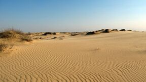
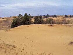
 Central part of Oleshky Sands in spring | |
| Lua error in Module:Location_map at line 408: Malformed coordinates value. | |
| Area | 1,612 km2 (622 sq mi) |
| Geology | |
| Type | Sand desert |
| Geography | |
| Country | Script error: No such module "Compact list". |
| State | Script error: No such module "Compact list". |
| Region | Script error: No such module "Compact list". |
| District | Script error: No such module "Compact list". |
| Population center | Script error: No such module "Compact list". |
| Borders on | Script error: No such module "Compact list". |
| Coordinates | [ ⚑ ] |
| River | Script error: No such module "Compact list". |
| Lake | Script error: No such module "Compact list". |
Oleshky Sands (Ukrainian: Олешківські піски) is a desert in Ukraine .[1] It is situated inland from the Ukraine coast of the Black Sea and consists of sand dunes or kuchuhury (locally), which reach a height up to five meters. A sparse vegetation can be located across the sands.
Origin
The sands are thought to be formed during the most recent ice age by aeolian processes accumulating and forming cliffs of lower parts of nearby River Dnieper. It is speculated that the amount of vegetation was reduced by herds of sheep who were introduced there by Friedrich-Jacob Eduardovych Falz-Fein who used the sands, formerly populated by weeds, as a pasture.[2][3]
Geography
The Oleshky Desert is located in Kherson Raion, Kherson Oblast, 30 km (~20 mi) east of Kherson. Before the Russian annexation of the Crimean Khanate at the end of the 18th century, the territory belonged to the nomad Nogai Hordes, particularly the Djambuilut Horde. No detailed historical information about the region has survived.
The closest populated settlement is seven kilometers away (~4.5 mi). In Soviet times the sands were used as an Soviet Air Force bombing range for pilots of the Warsaw Pact alliance. To this day there is a possibility of finding some unexploded ordnance.
Environment
Due to its temperature and the amount of precipitation, the area is sometimes described as a semi-desert. Oleshky Sands are around 15 kilometres (9 mi) across and are surrounded by a dense afforestation, planted to prevent dunes moving. Due to its density, the forest often catches fire. Although a relatively small sandy steppe, the Oleshky Sands have sandstorms.[4] They occur as the type of the sand is very fine and is easily picked up by a wind. The intensity of the sandstorms is rather weak. Beneath the sands, at a depth of around 35 metres (115 ft), there is an underground lake, which forms an essential part of the local environment.[citation needed]
2023 inundation
On 6 June 2023, following the destruction of the Kakhovka Dam, floodwaters from the surging Dnipro River flowed into the Oleshky Sands depression. Ukrainian ecologists believe this will seriously impact its ecosystem.[5]
See also
- Askania-Nova
- Cumania
- Deliblato Sands
- Oleshky Sands National Nature Park
References
- ↑ Sometimes Oleshky Sands are declared the largest desert (or sands) in Europe, but the largest sandy desert in Europe is Ryn Desert (40,000 km²), it is 20 times larger
- ↑ "Oleshky Sands National Nature Park" (in en-GB). https://wownature.in.ua/en/parks-and-reserves/oleshky-sands-national-nature-park/.
- ↑ "Oleshky Sands" (in en). 2019-10-31. https://earthobservatory.nasa.gov/images/145801/oleshky-sands.
- ↑ Blogsite(in Russian)
- ↑ "'Biggest ecocide in Ukraine': Thousands of species threatened by breach at Kakhovka Dam" (in en). 2023-06-07. https://www.euronews.com/2023/06/07/biggest-ecocide-in-ukraine-thousands-of-species-threatened-by-breach-at-kakhovka-dam.
External links
- Oleshky Sands overview — Seven Wonders of Ukraine. (in Ukrainian)
- Video footage of the desert, a video footage of the desert is provided by a blog-site of the local adventurers to familiarize the world with Ukraine.
- Desert, an excellent blog-site of Anna Stepankova with plenty of pictures and explanations. The problem might be with a language barrier as the site is in Russian, but the amount of pictures presented defeats that issue.
- Odesa Club of the extreme automobile touring, all pictures with vehicles driving across country areas.
- Oleshky Sands (Алешковские пески), more pictures of sand dunes.
- Three days through a forest, two - across fields (in Russian) a travel story through the Oleshky Sands with pictures.
- Singing Sands by Vladimir Chivilikhin (in Russian), a reflection story about the desert. Interviews with local scientists, historical research, other.
- An informational site about underground waters in the area (in Russian)
[ ⚑ ] 46°35′00″N 33°03′00″E / 46.5833333°N 33.05°E


